
Powerful Arctic Cold Front Rips Through Southeast Wyoming and Northern Colorado, Slamming Temperatures and Triggering 40–50 MPH Wind Gusts
WYOMING & COLORADO — A fast-moving Arctic cold front surged south through Cheyenne, Wyoming, and northern Colorado on Tuesday, causing temperatures to plunge into the teens within minutes while north winds gusted between 40 and 50 mph, producing dangerous wind chills and rapidly deteriorating conditions.
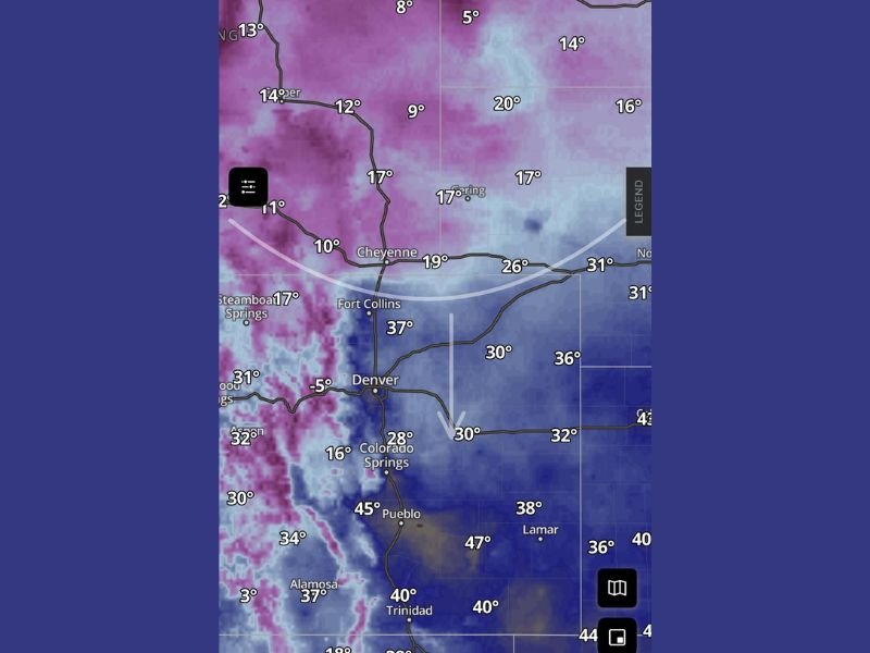
The frontal boundary is clearly visible on temperature and wind analysis, showing a sharp divide between sub-freezing Arctic air north of the front and much warmer air still lingering to the south.
Cheyenne Sees Rapid Temperature Collapse
As the cold front pushed through Cheyenne, temperatures fell sharply into the teens, confirming the arrival of a true Arctic air mass. Nearby locations north and west of Cheyenne quickly dropped into the single digits, while areas just south of the boundary remained significantly warmer for a short time.
This type of rapid temperature drop is typical of high-velocity Arctic fronts, where cold air surges southward faster than most weather systems.
Strong North Winds Intensify the Impact
Behind the front, north winds gusting 40–50 mph dramatically increased the severity of the cold. Even where air temperatures hovered in the teens or low 20s, wind chills plunged well below zero, making outdoor exposure dangerous.
These winds are strong enough to:
- Create blowing snow in areas with existing snow cover
- Reduce visibility during brief snow showers
- Increase the risk of frostbite in exposed skin
Snow Showers Accompany the Arctic Surge
The cold front also triggered scattered snow showers, especially across higher terrain and areas immediately behind the boundary. While snowfall amounts appear limited, the combination of gusty winds and falling temperatures can cause slick roads and rapidly changing travel conditions.
Sharp Temperature Contrast Across the Front
The data shows an extreme temperature gradient across a relatively small distance:
- Teens and single digits north of Cheyenne
- Upper 20s to 30s near Denver and Colorado Springs
- 40s farther south toward Pueblo and Lamar
This confirms the front is still actively pushing south, with colder air continuing to expand into eastern Colorado.
What to Expect Over the Next Several Hours
As the Arctic air continues advancing:
- Temperatures will continue falling behind the front
- Wind chills will remain dangerously low
- Any lingering moisture could quickly freeze on roads and surfaces
Residents are urged to limit time outdoors, secure loose objects due to strong winds, and prepare for rapidly changing conditions. Stay informed with ongoing weather updates and share your local conditions with us at NapervilleLocal.com.

I’ve lived in Naperville long enough to see how quickly our community changes — from new developments downtown to sudden shifts in our Midwest weather. Reporting on Naperville news and daily forecasts gives me the chance to keep neighbors informed about what really matters. My goal is simple: deliver clear, timely updates so you always know what’s happening in our city and what to expect from the skies above.