
Powerful Bering Sea Low to Slam Alaska with Blizzard Conditions, 60 mph Gusts, and Heavy Snowfall
ANCHORAGE, Alaska — A powerful Bering Sea low-pressure system is set to bring widespread winter storm conditions across western and southern Alaska beginning Sunday night and lasting through Monday, forecasters warn. The storm is expected to produce blizzard-level winds, heavy snowfall, and near-zero visibility, creating dangerous travel conditions across multiple regions.
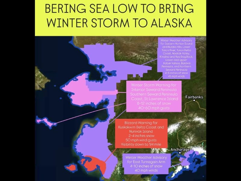
According to the National Weather Service (NWS), the intense system will track just off Alaska’s west coast, drawing Arctic air into the state while fueling bands of snow and strong gusts across the Seward Peninsula, Yukon Delta, and Kuskokwim Delta regions.
“This will be a high-impact winter event for coastal and interior western Alaska,” meteorologists said. “Winds could gust up to 60 mph with periods of heavy snow and whiteout conditions.”
Widespread Warnings in Effect Across Western Alaska
The NWS has issued multiple winter alerts as the Bering Sea low moves in:
- Blizzard Warning — Kuskokwim Delta Coast and Nunivak Island
- Snowfall: 2–4 inches
- Winds: Up to 50 mph gusts
- Visibility: Reduced to ¼ mile or less at times
- Winter Storm Warning — Interior and Southern Seward Peninsula, St. Lawrence Island
- Snowfall: 8–12 inches
- Wind Gusts: 40–60 mph
- Winter Weather Advisory — Eastern Norton Sound, Yukon Delta Coast, and Kobuk Valleys
- Snowfall: 4–8 inches
- Winds: 45 mph gusts
- Winter Weather Advisory — East Turnagain Arm
- Snowfall: 4–10 inches
- Winds: 40 mph gusts
Officials say the storm will deliver a complex mix of snow, strong winds, and blowing snow, especially along coastal areas and mountain passes.
Travel Expected to Be Extremely Difficult
The combination of heavy snowfall and gale-force winds will make travel hazardous or impossible in parts of western Alaska, particularly through St. Lawrence Island, Nunivak Island, and the Kuskokwim Delta Coast.
Drivers are urged to avoid non-essential travel during the height of the storm and prepare for rapidly changing conditions.
“Visibility could drop to near zero in blizzard areas, especially overnight Sunday into early Monday,” said the Alaska Weather Service. “Those who must travel should carry winter survival gear and expect delays or road closures.”
Aviation and marine travel are also expected to be disrupted, with low visibility, rough seas, and crosswinds likely impacting smaller aircraft and fishing vessels near the Bering and Norton Sounds.
Strong Winds and Coastal Impacts
Wind gusts up to 60 mph could lead to blowing snow, drifting roads, and minor coastal flooding in vulnerable areas. Power outages are also possible, particularly in rural communities where infrastructure is more exposed.
Meteorologists say the most intense conditions will likely occur overnight Sunday through midday Monday, when the storm center passes near the Seward Peninsula before weakening over the mainland interior.
“The combination of heavy snow and sustained winds will make this one of the strongest early-season storms Alaska has seen this month,” forecasters added.
Timing and Forecast Outlook
- Sunday Evening: Snow begins along the west coast, intensifying overnight.
- Monday Morning: Heaviest snow and strongest winds expected; blizzard warnings in effect.
- Monday Afternoon: Storm tracks inland, with snow gradually tapering off in western regions.
- Tuesday: Lighter snow showers persist in the interior as temperatures remain below freezing.
Forecasters expect temperatures to stay in the teens and 20s, with wind chills making it feel closer to zero degrees across western Alaska.
Residents Urged to Prepare for Power Outages and Delays
The Alaska Division of Homeland Security and Emergency Management is advising residents to prepare for potential power outages, limited travel, and supply interruptions over the next 24–36 hours.
Officials recommend:
- Keeping extra food, water, and fuel on hand.
- Checking generator functionality and battery-powered lights.
- Avoiding outdoor travel during peak wind and snow conditions.
- Securing loose outdoor items to prevent wind damage.
Local authorities have also warned that school closures and flight delays are possible Monday if the system maintains its current intensity.
Cold Pattern to Continue Through Midweek
Once the Bering Sea storm weakens, cold Arctic air will remain entrenched across much of Alaska through midweek, keeping high temperatures well below freezing.
Light snow and gusty winds could persist into Tuesday and Wednesday, particularly in coastal areas and high terrain.
Meteorologists say this storm marks the beginning of a more active winter pattern, with another potential system expected to approach from the North Pacific later in the week.
Residents are urged to monitor updated forecasts and warnings through the National Weather Service in Fairbanks and Anchorage.
Stay with NapervilleLocal.com for ongoing updates on major U.S. and Alaska weather systems as this Bering Sea low continues to evolve.

I’ve lived in Naperville long enough to see how quickly our community changes — from new developments downtown to sudden shifts in our Midwest weather. Reporting on Naperville news and daily forecasts gives me the chance to keep neighbors informed about what really matters. My goal is simple: deliver clear, timely updates so you always know what’s happening in our city and what to expect from the skies above.