
Powerful Cold Front to Sweep Across Texas, Dropping Temperatures from 70s to 50s and Bringing Freeze Risk to San Antonio
SAN ANTONIO, TEXAS — A strong cold front will surge across Texas this weekend, sending temperatures plunging by nearly 20 degrees and ushering in the first potential freeze of the season for parts of the state, including San Antonio.
The front is expected to arrive late Saturday night, sweeping south through Dallas, Houston, and San Antonio by early Sunday morning. Highs that reached the mid-70s on Saturday will be replaced by cool, windy 50s on Sunday, with temperatures continuing to fall through the morning.
Windy Sunday as Arctic Air Pushes South
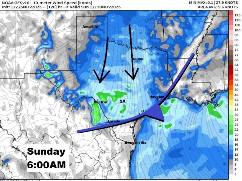
Forecast data from the NOAA GFS model shows a strong push of cold, dense air diving through the central plains into Texas. By 6 a.m. Sunday, the leading edge of the cold front will stretch from Del Rio to Houston, driving gusty north winds up to 30 mph across central and southern regions.
Wind chills will make the air feel even colder, especially during early morning hours when gusts are strongest.
“This front will be a major shift for Texans who’ve been enjoying mild afternoons,” one meteorologist explained. “By sunrise Sunday, most areas north of I-10 will feel like it’s winter.”
San Antonio Could See First Freeze Next Week
The cold surge won’t stop at the weekend. As high pressure builds behind the front, forecasters expect clear skies and calm winds, setting the stage for cold mornings through midweek.
San Antonio could flirt with 32°F as early as Tuesday morning, marking its first freeze of the season if conditions align.
Residents are urged to cover plants, protect pets, and check heating systems ahead of the temperature drop.
Temperature Breakdown Across Texas
- Saturday: Highs in the 70s, breezy and warm statewide
- Sunday: Highs fall to the 50s with strong winds from the north
- Monday–Tuesday: Morning lows near freezing across parts of central Texas
- Later Week: Gradual warming expected with highs rebounding into the 60s
Travel and Outdoor Impacts
With gusty winds expected behind the front, drivers should anticipate crosswinds on major north–south routes, including I-35 and U.S. 281. Outdoor events on Sunday may feel significantly colder due to wind chill.
“This is the kind of cold front that reminds everyone winter is on the way,” forecasters added. “Texas will go from late fall warmth to early winter chill almost overnight.”
Stay informed on local temperature drops, wind alerts, and freeze warnings — visit NapervilleLocal.com for full weather coverage and updates.

I’ve lived in Naperville long enough to see how quickly our community changes — from new developments downtown to sudden shifts in our Midwest weather. Reporting on Naperville news and daily forecasts gives me the chance to keep neighbors informed about what really matters. My goal is simple: deliver clear, timely updates so you always know what’s happening in our city and what to expect from the skies above.