
Powerful Cold System Expected to Impact Southern California and Arizona as “Raiden Storm Pattern” Returns Post-Thanksgiving
CALIFORNIA — Meteorologists are tracking a cold upper-level system forming over Southern California and Arizona, expected to arrive at the end of November and continue into early December. The pattern, known as the Raiden Storm, is forecast to bring strong winds, significant temperature drops, and widespread rain to much of the Southwest.
According to meteorologist Raiden Storm, who originally identified the pattern earlier this season, the upcoming event aligns with his cold and wet winter forecast, which had predicted an active start to Meteorological Winter beginning December 1.
Storm Pattern and Forecast Details
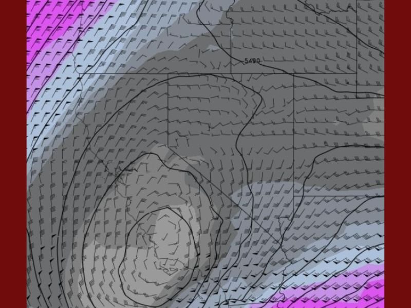
The “Raiden Storm Pattern” is defined as a low-pressure system moving into the Southwest, pulling in cold Arctic air and Pacific moisture. Models indicate that this system has “a lot of power and cold air with it,” potentially resulting in snow at higher elevations and below-average temperatures for inland valleys.
Storm emphasized that this weather event was forecasted weeks ahead of other outlets, noting that early signs of the returning pattern were visible shortly after Thanksgiving.
“This one has a lot of cold air and energy behind it,” Storm stated. “It’s part of a return to the pattern I identified earlier this fall, signaling a colder and wetter end to November.”
Impacts for the Southwest
- Southern California: Expect rain, gusty winds, and colder temperatures, especially across Los Angeles, Riverside, and San Bernardino counties.
- Arizona: The system could bring snow to northern regions, including Flagstaff and the Mogollon Rim, with rain and dropping temperatures elsewhere.
- Nevada and New Mexico: Portions of these states may also see spillover effects, including scattered precipitation and strong winds.
Residents are encouraged to monitor local forecasts and prepare for colder mornings and potential travel impacts at higher elevations as the storm strengthens toward the beginning of December.
Outlook for December
The National Weather Force, led by Raiden Storm, expects the Raiden pattern to persist into early winter, with additional storm systems likely through mid-December.
“This aligns perfectly with the seasonal forecast calling for a cold and wet winter start,” Storm added.
For continued weather updates and storm tracking across the U.S., follow NapervilleLocal.com.

I’ve lived in Naperville long enough to see how quickly our community changes — from new developments downtown to sudden shifts in our Midwest weather. Reporting on Naperville news and daily forecasts gives me the chance to keep neighbors informed about what really matters. My goal is simple: deliver clear, timely updates so you always know what’s happening in our city and what to expect from the skies above.