
Powerful Mid-Atlantic Winter Storm Takes Shape as Offshore Low Signals Heavy Snow, Strong Winds, and Near-Blizzard Conditions
Mid-Atlantic and Southeast United States — A significant winter storm is coming into sharper focus for the Mid-Atlantic as forecast models show an offshore low-pressure system setting up in a near-ideal position to deliver heavy snowfall, strong winds, and potentially near-blizzard conditions across a wide portion of the eastern U.S. through the weekend.
New snowfall projections indicate substantial accumulations from the Carolinas northward, with impacts extending as far south as Georgia and South Carolina and eastward toward Atlantic coastal communities, including beach regions that rarely experience heavy winter weather.
What Forecast Models Are Showing
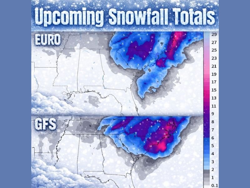
Latest snowfall maps from both the EURO and GFS models point to a broad swath of accumulating snow across the eastern half of the country. The heaviest snowfall signal stretches from the southern Appalachians through the central and eastern Mid-Atlantic, where model guidance shows widespread moderate to heavy totals.
Several inland areas show snowfall potential well above typical winter events for the region, while coastal zones may see heavy, wind-driven snow depending on the storm’s final track. Forecasters note that the offshore low’s placement is critical, and current data suggests it is aligning favorably to pull cold air and moisture together.
Snowfall Totals Could Be Significant
Model projections suggest multi-inch snowfall totals across large areas, with localized higher amounts possible where snow bands persist. Portions of the Carolinas, Virginia, and nearby states could see snow totals climbing into the upper single digits or higher, particularly under stronger banding features.
Farther south into Georgia and South Carolina, snowfall amounts are expected to be lower overall but still impactful given the region’s limited winter weather infrastructure. Even modest accumulations in these areas can lead to major disruptions.
Strong Winds Raise Blizzard-Like Concerns
In addition to snow, forecasters are monitoring strong wind potential associated with the developing storm. Gusty conditions could combine with falling snow to significantly reduce visibility, creating near-blizzard conditions in some locations, especially in exposed and coastal areas.
Strong winds may also contribute to drifting snow, hazardous travel, and isolated power outages if heavy snow accumulates on trees and power lines.
Coastal and Travel Impacts Likely
The storm’s reach toward the Atlantic coastline raises concerns for coastal travel corridors, including bridges and elevated roadways that can become dangerous quickly in winter conditions. Beach communities that rarely see snow may experience difficult travel conditions if precipitation remains frozen.
Air and ground travel disruptions are increasingly likely as the storm evolves, particularly during peak travel periods over the weekend.
Why This Storm Is Being Watched Closely
Meteorologists emphasize that this storm combines several high-impact ingredients: a well-positioned offshore low, ample moisture, strong winds, and cold air in place. While exact snowfall totals and impact zones will continue to be refined, confidence is growing that this will be a high-impact winter storm for parts of the Mid-Atlantic and Southeast.
Residents across the affected regions are urged to monitor updates closely, prepare for changing conditions, and plan for potential travel disruptions.
As forecast confidence continues to increase, NapervilleLocal.com will keep tracking this major winter storm and its regional implications, including broader travel and supply impacts that may extend beyond the immediate storm zone.

I’ve lived in Naperville long enough to see how quickly our community changes — from new developments downtown to sudden shifts in our Midwest weather. Reporting on Naperville news and daily forecasts gives me the chance to keep neighbors informed about what really matters. My goal is simple: deliver clear, timely updates so you always know what’s happening in our city and what to expect from the skies above.