
Powerful Midweek Storm System to Bring Severe Thunderstorms, Heavy Rain, and Flooding Across Texas and Oklahoma
TEXAS — A powerful storm system moving into the Southern Plains is set to unleash rounds of severe thunderstorms, heavy rainfall, and localized flooding across Texas and Oklahoma beginning Wednesday afternoon, lasting into Friday morning, according to updated weather outlooks.
The system will intensify as it sweeps eastward, drawing in moist Gulf air that fuels widespread thunderstorms. Central and southern Texas, including Austin, San Antonio, and Waco, are expected to see the most intense activity, while northern Texas and southern Oklahoma could face periods of heavy rain and gusty winds.
Severe Storms Expected to Peak Wednesday Afternoon and Evening
Forecasters warn that storm development will begin late Wednesday afternoon, continuing through the night as the cold front moves across the region.
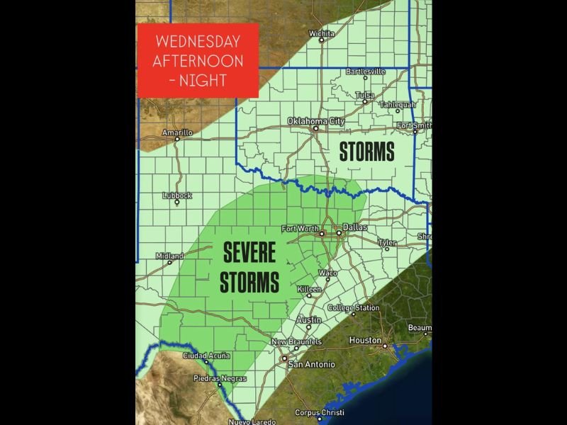
- Central and South Texas: The highest risk zone for damaging winds, hail, and isolated tornadoes. Cities including San Antonio, Killeen, and Fort Worth are highlighted in the “Severe Storms” area.
- Oklahoma: From Oklahoma City to Tulsa, the main concern is torrential rain and frequent lightning, with isolated stronger storms possible.
- Flooding Risk: The combination of slow-moving storms and saturated soils may lead to flash flooding, particularly in urban zones and low-lying areas.
Meteorologists say 2 to 4 inches of rainfall could occur in parts of Texas, with locally higher totals possible where storms repeatedly pass over the same areas.
Thursday Into Friday: Continued Rain and Flood Threat
By Thursday, the storm system is expected to expand eastward into Houston, Dallas, and Shreveport, keeping rain and thunderstorm chances elevated across the region.
- The severe threat will gradually lessen, but heavy rain and flood risks will persist through Friday morning.
- Travelers heading out for Thanksgiving week should prepare for delays, poor driving conditions, and reduced visibility.
Officials Urge Preparedness Ahead of Potentially Dangerous Conditions
Authorities are reminding residents to stay alert for weather alerts and to have a plan in place should conditions worsen overnight.
- Avoid driving through flooded roadways; even a few inches of moving water can be life-threatening.
- Secure outdoor objects and decorations that could be displaced by strong winds.
- Keep phones charged and ensure emergency notifications are enabled for local warnings.
Weather experts emphasize that storm strength and timing could still shift slightly as models update, but the risk for severe weather and flooding across Texas and Oklahoma remains significant through the end of the week.
Stay with NapervilleLocal.com for continued coverage and weather safety updates.

I’ve lived in Naperville long enough to see how quickly our community changes — from new developments downtown to sudden shifts in our Midwest weather. Reporting on Naperville news and daily forecasts gives me the chance to keep neighbors informed about what really matters. My goal is simple: deliver clear, timely updates so you always know what’s happening in our city and what to expect from the skies above.