
Powerful Thunderstorm Line From Louisiana Through Mississippi Into Alabama Brings Hail, Damaging Winds and Possible Tornado Threat Tonight
LOUISIANA, MISSISSIPPI, ALABAMA — A strong line of thunderstorms is sweeping across the Gulf South tonight, stretching from Louisiana through Mississippi and into Alabama, bringing intense rainfall, strong wind gusts, hail, and a small chance of tornadoes.
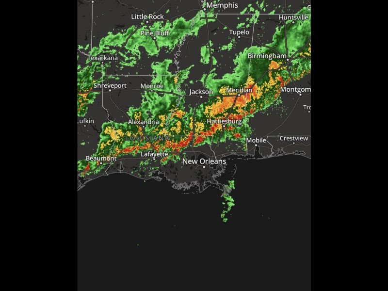
Weather radar shows a long band of storms extending across southern Louisiana into southern Mississippi and pushing toward western Alabama, with the most intense activity moving through areas including Lafayette, Alexandria, and Beaumont in Louisiana, then eastward toward Hattiesburg and Meridian in Mississippi, and eventually toward Birmingham and Montgomery in Alabama.
Meteorologists say the storms are organized into a strong line capable of producing several severe weather hazards as it moves east across the region.
Damaging Winds and Large Hail Possible in Stronger Storm Cells
Within the storm line, conditions are favorable for powerful wind gusts capable of knocking around loose outdoor items and causing localized damage. These winds often develop when thunderstorms form tightly organized lines, allowing gust fronts to push rapidly ahead of the storms.
Large hail is also possible in the strongest storms. Strong updrafts inside thunderstorms lift moisture high into the atmosphere where ice forms and grows before falling back to the ground as hail.
Some of the more intense cells embedded within the storm line could also rotate briefly, meaning a small tornado threat cannot be ruled out as the system moves through parts of Mississippi and Alabama tonight.
Radar Shows Strongest Storms Along the Gulf Coast Corridor
Radar imagery indicates the most intense portion of the storm line currently stretches from near Lafayette, Louisiana eastward across Hattiesburg, Mississippi, and continues toward central Alabama.
Bright red and orange radar returns highlight areas of heavy rainfall and strong thunderstorms, while surrounding green areas show lighter rain bands and scattered storms.
Communities near New Orleans and along the Gulf Coast are also experiencing heavy rainfall as storms move through the region. Meanwhile, farther north toward Little Rock, Pine Bluff, and Memphis, storms appear more scattered and less organized compared to the powerful southern line.
Storm Line Expected to Push East Through the Night
Forecasters expect the thunderstorm line to continue moving east across Mississippi and Alabama through the evening and overnight hours, gradually weakening as atmospheric conditions become less supportive.
However, strong storms may still produce sudden bursts of wind, lightning, heavy rain, and pockets of hail before the system finally loses strength later tonight.
Residents in areas along the storm’s path are encouraged to stay indoors during the strongest storms and remain alert for rapidly changing weather conditions, especially if warnings are issued locally.
As the storm line progresses eastward, conditions should gradually improve behind it once the main band of storms moves through the region.

I’ve lived in Naperville long enough to see how quickly our community changes — from new developments downtown to sudden shifts in our Midwest weather. Reporting on Naperville news and daily forecasts gives me the chance to keep neighbors informed about what really matters. My goal is simple: deliver clear, timely updates so you always know what’s happening in our city and what to expect from the skies above.