
Powerful Windstorm Expected Friday Across Ohio and Michigan With Gusts Near 60 MPH That Could Cause Tree and Roof Damage
TOLEDO, OHIO — A Weather Impact Alert Day has been issued for Friday across parts of Ohio and southern Michigan, where strong winds are expected to intensify throughout the day and could produce gusts approaching 60 mph, raising concerns about tree damage, loose siding, and potential roof issues.
Meteorologists say the event will not resemble the severe thunderstorms seen earlier this week, but instead will be driven primarily by strong atmospheric winds moving through the region, capable of producing damaging gusts even without widespread thunderstorms.
Wind Gusts Increasing Through the Morning
Forecast models show winds beginning to pick up during the morning hours Friday, gradually strengthening as the day progresses.
The strongest winds are expected during the late morning through the afternoon, with the most intense gusts likely occurring between 11 a.m. and 6 p.m.
During this time, wind speeds could easily exceed 50 mph across several communities in northwest Ohio and southern Michigan.
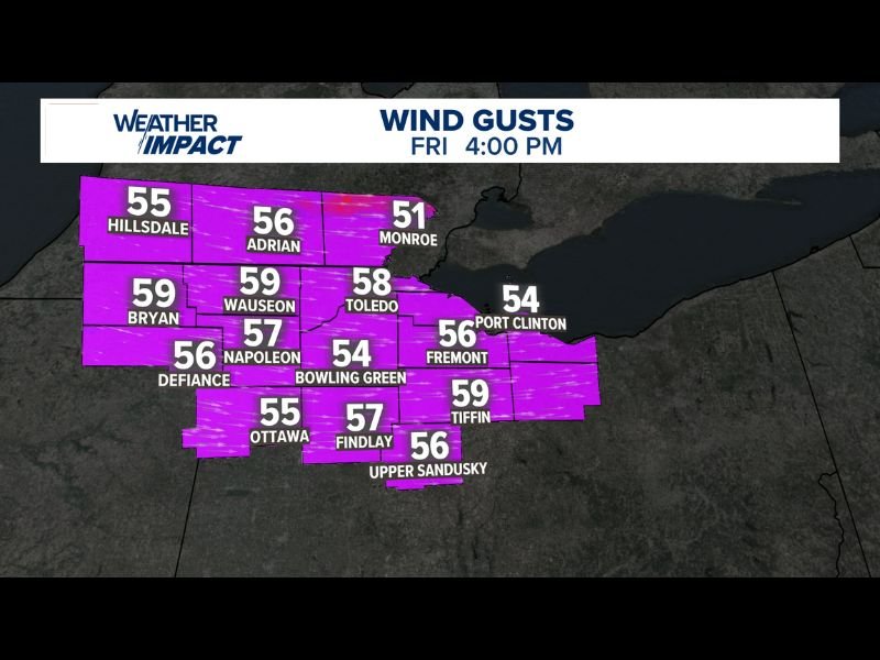
Cities Across Northwest Ohio Expect Strongest Gusts
Forecast wind projections indicate widespread strong gusts across the region by Friday afternoon, including:
- Bryan: up to 59 mph
- Wauseon: around 59 mph
- Toledo: near 58 mph
- Napoleon: about 57 mph
- Findlay: around 57 mph
- Fremont: roughly 56 mph
- Upper Sandusky: about 56 mph
- Ottawa: near 55 mph
- Hillsdale (MI): about 55 mph
- Port Clinton: near 54 mph
- Bowling Green: roughly 54 mph
- Monroe (MI): around 51 mph
These gusts could be strong enough to knock down small tree limbs, move unsecured outdoor objects, and cause isolated power outages.
Winds Shifting Direction During the Day
Meteorologists expect the wind pattern to begin as a southwest flow during the morning, gradually shifting more westerly later in the day as the weather system progresses across the region.
This shift may allow stronger gusts to develop during the peak afternoon hours as pressure gradients tighten behind the passing system.
Conditions Expected to Improve Overnight
While winds will remain breezy Friday evening, forecasts suggest gusts should begin weakening overnight into Saturday morning, allowing conditions to gradually improve across the region.
However, officials advise residents to secure outdoor furniture, trash bins, and loose objects ahead of the strongest winds Friday afternoon.
Drivers, especially those operating high-profile vehicles, should also be prepared for sudden crosswinds during the peak of the wind event.

I’ve lived in Naperville long enough to see how quickly our community changes — from new developments downtown to sudden shifts in our Midwest weather. Reporting on Naperville news and daily forecasts gives me the chance to keep neighbors informed about what really matters. My goal is simple: deliver clear, timely updates so you always know what’s happening in our city and what to expect from the skies above.