
Powerful Winter System Targets Florida and the East Coast as Deep Arctic Air, Southern Snow Potential, and Nor’easter Signals Emerge
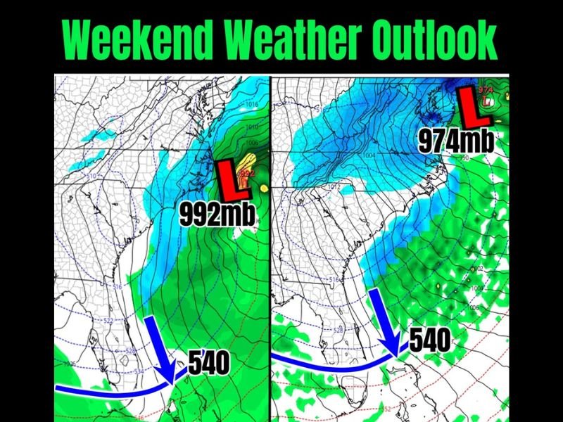
FLORIDA — Meteorologists are closely monitoring a high-impact winter pattern setting up for the upcoming weekend, as a strong frontal boundary plunges unusually far south into Florida, signaling just how intense the cold air mass will be. Forecast data shows the critical 540 thickness line diving deep into the Southeast, a classic indicator that air cold enough to support snow is reaching regions that rarely see it.
At the same time, attention is turning to the Eastern Seaboard, where conditions are increasingly favorable for the development of a classic Nor’easter, potentially bringing snow and wintry weather to parts of the Mid-Atlantic before impacts shift northward.
Why the 540 Line Has Meteorologists Concerned
One of the most striking signals in the forecast is the 540 thickness line pushing well into Florida, something rarely observed. This benchmark is commonly used by meteorologists to identify air masses cold enough to support snow, especially when precipitation is present.
The deeper this line moves south, the stronger the Arctic air intrusion, and current projections show a cold pool capable of producing record-challenging temperatures across much of the Southeast.
Southern Snowflakes Back on the Table
With such cold air pressing southward, some forecast models are once again teasing the possibility of snowflakes reaching parts of the Deep South. While this remains a low-confidence scenario, even the suggestion highlights how unusual and powerful this pattern has become.
Any southern snow would depend on precise timing between the cold air and available moisture, something that will continue to be refined as the weekend approaches.
Developing Nor’easter Along the East Coast
As the Arctic air dives south, energy is expected to transfer offshore along the East Coast, creating the setup for a developing low-pressure system over the Atlantic. This is a classic pathway for Nor’easter development, especially during mid-winter patterns like this.
If the storm strengthens as projected, parts of the Mid-Atlantic could see accumulating snow, with impacts potentially spreading northward into the Northeast — a progression that historically aligns with similar setups.
What Happens Next
Meteorologists stress that this is a pattern to watch closely, not a single-model outlier. Multiple data sources are signaling a significant winter escalation, with impacts ranging from dangerous cold in the South to potential snow along the East Coast. Forecast confidence will continue to increase over the next several days as the system comes into sharper focus.
For continued updates on major winter weather patterns and how national systems connect back to the Midwest, stay with NapervilleLocal.com and check back often as this evolving situation unfolds.

I’ve lived in Naperville long enough to see how quickly our community changes — from new developments downtown to sudden shifts in our Midwest weather. Reporting on Naperville news and daily forecasts gives me the chance to keep neighbors informed about what really matters. My goal is simple: deliver clear, timely updates so you always know what’s happening in our city and what to expect from the skies above.