
Rain Focuses on Eastern North Carolina While Fog and 50s Dominate Friday — Western Areas Turn Quieter Ahead of Weekend Warmup
NORTH CAROLINA — A changing weather pattern is setting up across the state today, with the best rain chances shifting toward eastern and coastal communities while western areas turn quieter after a foggy start.
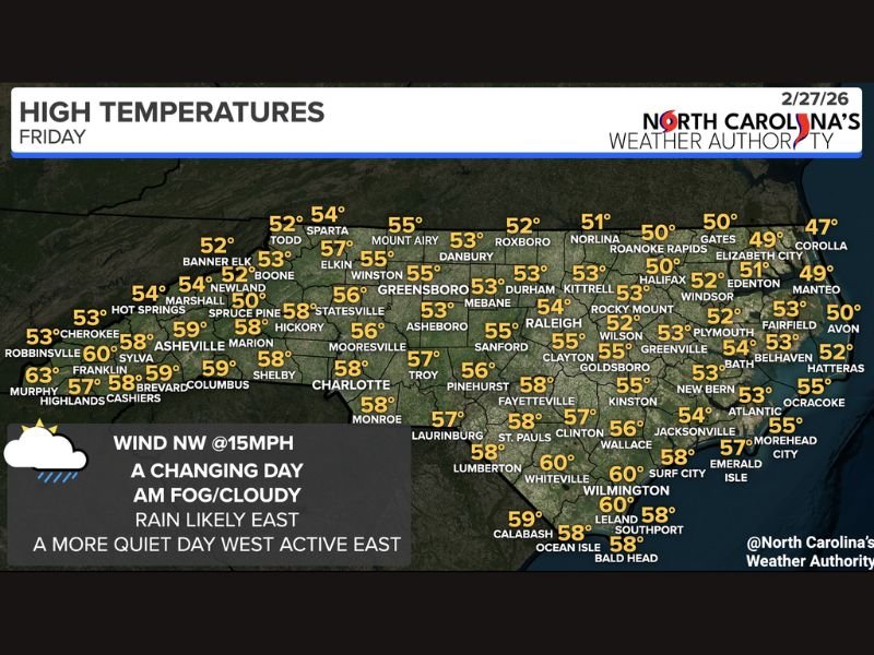
Friday begins with areas of clouds and patchy morning fog statewide, creating reduced visibility in some spots. Rain is already occurring across eastern counties, and that trend will continue through much of the day.
Rain Likely East, Limited Showers West
The primary focus for rainfall today will be across Eastern and Coastal North Carolina, where periods of rain are most likely. Cities such as:
- Greenville (53°)
- New Bern (53°)
- Jacksonville (56°)
- Wilmington (60°)
- Morehead City (55°)
- Elizabeth City (49°)
- Roanoke Rapids (50°)
can expect a damp day, with steady light rain at times.
Further west of Raleigh, including Greensboro (55°), Winston-Salem (55°), Charlotte (58°), Hickory (58°), and Asheville (59°), rainfall will be much more limited. Some drizzle is possible, but many western communities will experience a quieter afternoon compared to the coast.
High Temperatures Mainly in the 50s
Temperatures across the state will remain seasonably cool, with most communities topping out in the low to mid-50s, and a few southern locations reaching the upper 50s to around 60 degrees.
Here’s a closer look at regional highs:
- Raleigh: 54°
- Durham: 53°
- Sanford: 55°
- Fayetteville: 58°
- Goldsboro: 55°
- Greensboro: 55°
- Charlotte: 58°
- Asheville: 59°
- Wilmington: 60°
- Whiteville: 60°
Northern Outer Banks communities such as Corolla (47°) and Manteo (49°) will stay cooler under persistent cloud cover.
Northwest Winds and Improving Conditions West
Winds will shift to the northwest at around 15 mph, helping to gradually dry out western counties as the day progresses. The overall theme: a more active east, quieter west.
By evening, rain will taper, and the state will begin transitioning toward a warmer weekend setup.
Warmer Weekend Ahead
While Friday stays cool and cloudy, a noticeable warmup is expected this weekend. Temperatures statewide will trend milder, continuing the broader pattern shift toward more springlike conditions.
For today, keep an umbrella handy if you’re east of Raleigh, watch for morning fog, and expect improving conditions from west to east later in the day. For continued regional and national weather coverage, follow updates on NapervilleLocal.com.

I’ve lived in Naperville long enough to see how quickly our community changes — from new developments downtown to sudden shifts in our Midwest weather. Reporting on Naperville news and daily forecasts gives me the chance to keep neighbors informed about what really matters. My goal is simple: deliver clear, timely updates so you always know what’s happening in our city and what to expect from the skies above.