
Rain Slides Out of Alabama by Midday as 70s Take Over — Southeast Ridge to Deliver Near-80° Warmth Next Week
ALABAMA — A broad shield of rain is covering the southern half of the state early this morning, but drier air pushing in from the north will steadily shut it down by midday.
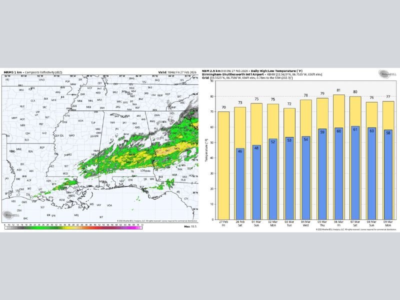
Radar shows the heaviest rain concentrated across south-central and southeast Alabama, gradually sliding southward toward the Gulf Coast. Communities from Montgomery to Dothan and eastward have been under the steadiest bands, while northern areas are already trending drier.
Midday Clearing, Comfortable Highs Today
As the rain exits, most locations will warm into the 68° to 74° range this afternoon. Skies will improve from north to south, with cloud cover lingering longest near the coast and far southeast.
The overall trend today:
- Morning rain south
- Gradual clearing by midday
- Mild, seasonable temperatures statewide
Weekend Outlook: Mild and Mostly Dry
Alabama’s weekend turns notably pleasant.
Saturday and Sunday will feature partly to mostly sunny skies, fair nights, and highs in the 70s statewide. The only exception is a small shower risk around Dothan on Saturday, but most communities will remain dry.
By Sunday, a few spots across South Alabama could flirt with 80 degrees, signaling a shift toward a warmer pattern.
Strong Ridge Builds Next Week
The bigger story arrives next week as a strong upper-level ridge builds over the Southeast United States. This pattern will:
- Keep storm systems west and north of Alabama
- Promote dry, stable weather
- Push temperatures above average
Highs Monday and Tuesday will remain in the 70s, followed by even warmer conditions later in the week.
Forecast guidance indicates temperatures could rise into the 76° to 84° range across the latter half of the week, marking a significant shift away from late-winter conditions.
The Bottom Line
- Rain exits southern Alabama by midday
- Highs today: upper 60s to mid 70s
- Weekend: Mostly dry, highs in the 70s
- Sunday: A few south Alabama locations near 80°
- Next week: Warm and dry with highs climbing into the 80s
After a damp start, Alabama is transitioning into a stretch of mild, springlike weather that could feel more like April than late February.
For continued regional and national weather coverage, stay connected with NapervilleLocal.com.

I’ve lived in Naperville long enough to see how quickly our community changes — from new developments downtown to sudden shifts in our Midwest weather. Reporting on Naperville news and daily forecasts gives me the chance to keep neighbors informed about what really matters. My goal is simple: deliver clear, timely updates so you always know what’s happening in our city and what to expect from the skies above.