
Rapidly Developing Storm Off the California Coast Expected to Accelerate North With Strong Winds and Model Uncertainty
United States — A rapidly intensifying storm system is forming well off the coast of Santa Barbara and Southern California, setting the stage for a fast-moving wind event expected to reach the Pacific Northwest within 24 hours. The developing low-pressure center was first identified offshore Tuesday afternoon, and meteorologists report that the system is accelerating at an unusual pace, projected to arrive near Seattle by midday Wednesday despite originating far to the south.
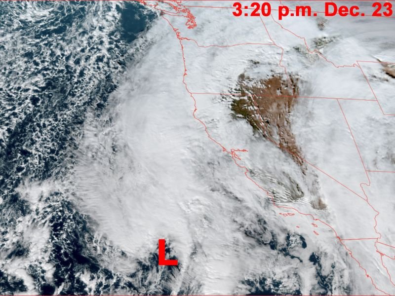
Rapid Formation Observed Off the Southern California Coast
Forecasters noted the storm’s low-pressure signature forming off the Southern California coastline, with satellite imagery showing the early signs of intensification. The rapid development has surprised some meteorologists, as systems forming this far south rarely travel northward this quickly.
The storm is expected to travel roughly 21 hours from formation to potential land influence, according to current projections. This unusually fast movement has made forecasting more difficult, with impacts likely to vary significantly depending on the storm’s final track.
Major Forecast Disagreement Among Weather Models
Tuesday afternoon brought a wide spread of outcomes across the leading forecast models, highlighting the challenge of predicting this system. Meteorologists outlined key differences:
- The European model is not forecasting a major windstorm, showing a weaker system with non-impactful winds.
- The American GFS model remains aggressive, keeping the storm center offshore. This track would result in stronger coastal and Northwest Interior winds, potentially above 60 mph, while producing 45–55 mph gusts for inland areas.
- The HRRR model, previously dismissive, has shifted into a middle-ground scenario, now showing a burst of winds around 45–50 mph.
- The NAM model continues to project extreme and unrealistic wind speeds, with some output showing 70 mph or higher, a scenario meteorologists caution against relying on due to the model’s tendency to over-amplify storms.
This range of solutions underscores the system’s complexity and the difficulty in pinpointing exact wind speeds ahead of its rapid northward movement.
High Wind Watch in Effect With Possible Upgrades Soon
As of 3:30 p.m., the region remains under a High Wind Watch, which will soon need to be upgraded to either a High Wind Warning or a Wind Advisory—depending on updated model guidance. A High Wind Warning would indicate expected gusts above 58 mph, while a Wind Advisory would signal gusts in the 40–55 mph range.
Meteorologists monitoring the system continue to emphasize caution. While there remains skepticism toward the most extreme scenarios, trends suggest that gusts in the 40–55 mph range are becoming increasingly likely, especially as the storm accelerates northward.
Travel Impacts Likely in a Narrow Wednesday Window
Due to the storm’s speed, impacts may be brief but intense. Some models show strong winds striking around Noon to 2 p.m., followed by a rapid drop to under 10 mph by dinnertime. This compressed timeline means travelers may face a narrow window of hazardous conditions.
Experts advise that Wednesday morning before noon or after 4 p.m. may be the safest times for travel, depending on the storm’s final track and timing.
With rapid development, conflicting model solutions, and a fast-moving system, forecasters stress the importance of closely monitoring updates into Wednesday morning. For ongoing national weather coverage and real-time storm analysis, stay connected with NapervilleLocal.com.

I’ve lived in Naperville long enough to see how quickly our community changes — from new developments downtown to sudden shifts in our Midwest weather. Reporting on Naperville news and daily forecasts gives me the chance to keep neighbors informed about what really matters. My goal is simple: deliver clear, timely updates so you always know what’s happening in our city and what to expect from the skies above.