
Rapidly Intensifying Hurricane-Strength Low Off the California Coast Expected to Drive Dangerous Winds on Christmas Eve
United States — A rapidly strengthening storm system off the California coast is forecast to reach hurricane-strength pressure levels as it races north toward the Pacific Northwest on Christmas Eve. Meteorologists report that the low-pressure center is deepening at an exceptional rate, creating the potential for damaging wind gusts and hazardous coastal conditions across the region.
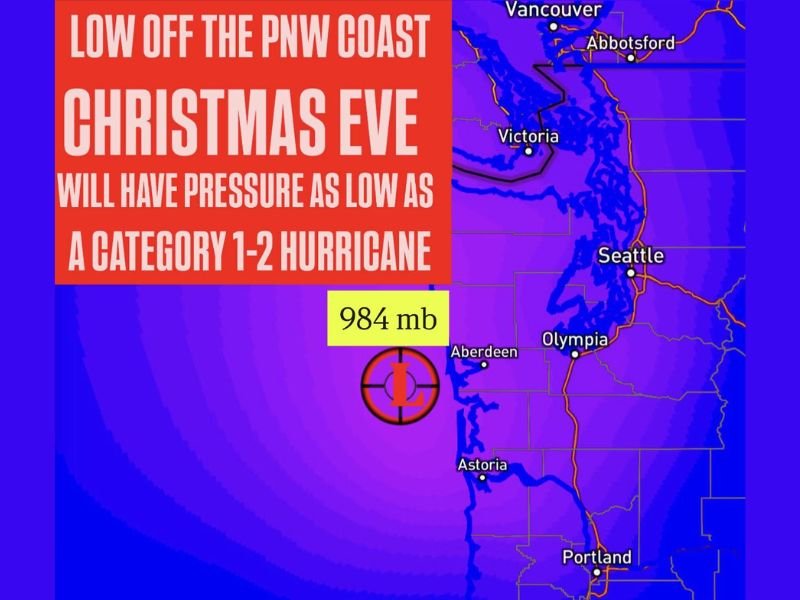
Storm Rapidly Intensifies Off the California Coast
According to early analysis, the low began intensifying late Tuesday along the California coastline, with pressure levels dropping quickly as the system organized. Forecasters warn that the low could deepen to pressures comparable to a high-end Category 1 or low-end Category 2 hurricane, based strictly on barometric intensity.
While the storm is not a tropical cyclone, its pressure values and wind potential fall within the range typically associated with hurricane-strength systems. This rapid deepening is expected to continue through the night and into Christmas Eve morning.
System to Race North Toward the Pacific Northwest on Christmas Eve
Once fully developed, the storm will accelerate northward off the Pacific Northwest coastline, maintaining unusually low pressure as it approaches land-influencing waters. As the system reaches peak intensity, it is expected to generate strong, damaging wind gusts, particularly near coastal headlands and exposed marine zones.
Forecast models show widespread areas of high wind potential, with gusts strong enough to:
- Disrupt regional holiday travel
- Produce hazardous marine conditions
- Challenge power infrastructure
- Down trees in locations exposed to sustained wind fields
The combination of hurricane-strength pressure and rapid movement raises concern for brief but severe weather impacts across the coastline.
Potential Impacts for Coastal Communities
Although the developing low is centered offshore, its influence may extend far inland depending on track and speed. Areas along the Pacific coastline — particularly those with elevated terrain or open exposure — could see intense wind bursts and shifting frontal bands as the system passes.
Forecasters caution that, due to the storm’s unusual strength, the following impacts are possible:
- Localized power outages from fallen branches or knocked-down lines
- Dangerous surf and coastal flooding, especially during high tide
- Hazardous marine conditions for vessels within offshore and near-shore zones
- Travel delays tied to strong crosswinds on bridges and open stretches of highway
Meteorologists emphasize that while this event is highly dynamic, confidence is increasing regarding the storm’s rapid intensification and the associated risk of widespread coastal wind damage on Christmas Eve.
Residents Encouraged to Monitor Local Updates
Given the potential severity of this offshore system, residents along the West Coast are urged to follow updates from regional National Weather Service offices. Conditions can shift rapidly as low-pressure systems tighten, and even slight changes in track could alter wind intensity and impact zones. For continuing national storm coverage, developing forecasts, and severe weather alerts, stay connected with NapervilleLocal.com.

I’ve lived in Naperville long enough to see how quickly our community changes — from new developments downtown to sudden shifts in our Midwest weather. Reporting on Naperville news and daily forecasts gives me the chance to keep neighbors informed about what really matters. My goal is simple: deliver clear, timely updates so you always know what’s happening in our city and what to expect from the skies above.