
Rare Euro Model Signal Shows 50% or Higher Chance of One-Foot Snowfall From Arkansas Through Tennessee, North Carolina, and Virginia
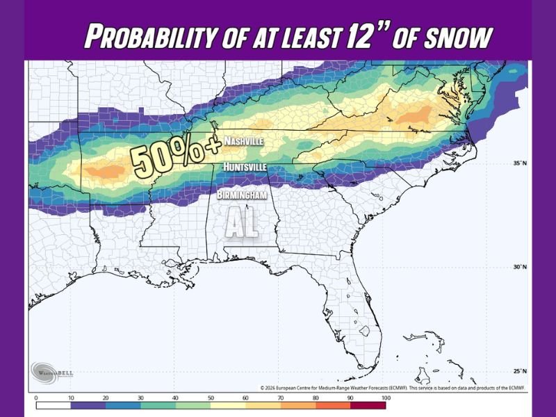
UNITED STATES — A highly unusual winter storm signal has emerged from the European AI Ensemble, indicating a 50% or greater probability of at least 12 inches of snow across a long corridor stretching from Arkansas through Tennessee into North Carolina and Virginia later this month.
This level of probability for a one-foot snowfall is extremely rare for the southern and central Appalachian region and immediately elevates this system into the high-impact winter storm category.
Why This Forecast Is Turning Heads
Meteorologists typically become concerned when probabilities show a 50% chance of even one inch of snow. In this case, the Euro ensemble is signaling something far more extreme — a realistic chance of double-digit snowfall totals across multiple states.
If this scenario materializes, it could rank among the most significant snow events seen in decades for parts of the southern and eastern interior United States.
Core Snow Corridor Identified by the Euro Ensemble
The highest snowfall probabilities are focused within a narrow but continuous band that includes:
- Arkansas
- Tennessee
- North Carolina
- Virginia
Within this corridor, probabilities exceed 50% for at least 12 inches of snow, especially near and east of central Tennessee and extending into the interior of North Carolina and southern Virginia.
Cold Air Adds to the Severity
Even outside the primary heavy snow axis, the data shows strong Arctic air pressing southward, supporting the potential for sub-zero temperatures in nearby areas.
Locations such as Huntsville, Decatur, and the Shoals in northern Alabama may not see the highest snow totals, but the cold air alone could bring dangerous wind chills and prolonged freezing conditions, increasing overall storm impacts.
Important Context About This Data
This forecast is based on European AI Ensemble guidance from Tuesday, January 20, 2026. Ensemble probabilities do not guarantee exact snowfall totals, but a signal of this strength and consistency is rare and notable. Forecasters stress that events with this level of modeled confidence do not occur often, even if later adjustments shift the exact placement of the heaviest snow.
What Happens Next
Additional model runs over the coming days will determine whether this high-end snowfall signal strengthens or weakens. However, the presence of a multi-state corridor with a 50% or greater chance of one foot of snow already places this system firmly on the radar.
Residents across Arkansas, Tennessee, North Carolina, and Virginia should closely monitor forecast updates and be prepared for potential travel disruptions and dangerous winter conditions.
Stay updated with continued winter weather coverage and share your preparation plans with us on NapervilleLocal.com.

I’ve lived in Naperville long enough to see how quickly our community changes — from new developments downtown to sudden shifts in our Midwest weather. Reporting on Naperville news and daily forecasts gives me the chance to keep neighbors informed about what really matters. My goal is simple: deliver clear, timely updates so you always know what’s happening in our city and what to expect from the skies above.