
Rare Mid-February Pattern Could Send Below-Normal Cold Into All 50 States as Polar Vortex Weakens
UNITED STATES — Confidence is growing among forecasters that mid-February will turn sharply colder than normal across much of the United States, with long-range models increasingly aligned on a widespread cold pattern developing during the third week of February.
While it remains uncertain just how cold temperatures may drop — or whether snow will accompany the cold — the broader signal is clear: below-normal temperatures are expected to intensify nationwide, driven by changes high in the atmosphere.
Sudden Stratospheric Warming Signals a Pattern Shift
Meteorologists are closely monitoring a Sudden Stratospheric Warming (SSW) event, which is expected to develop over the coming week. These events often lead to a weakening or splitting of the polar vortex, allowing Arctic air to spill southward into North America.
Historically, it can take one to two weeks after an SSW event for surface impacts to fully materialize. Current timing aligns closely with mid-to-late February, when the cold signal strengthens across long-range forecasts.
Long-Range Models Show Widespread Cold by Week Three
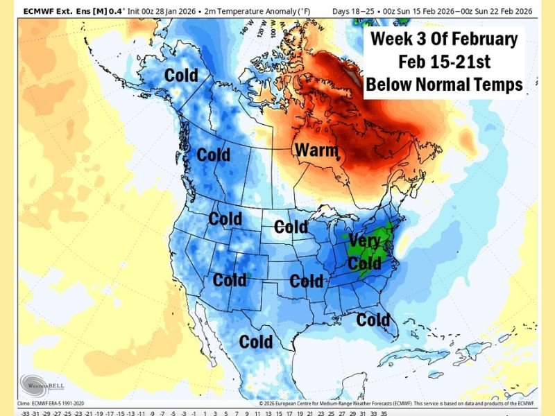
Every major long-range temperature outlook now shows below-normal temperatures expanding across the country during the February 15–21 window. Forecast anomaly maps depict cold air dominating much of the western, central, southern, and eastern United States simultaneously.
Early indications suggest:
- Broad cold anomalies across the Great Lakes, Midwest, Plains, South, and East Coast
- Colder-than-average conditions extending coast to coast
- Very limited regions escaping the cold pattern
A Rare Nationwide Cold Setup
What makes this pattern particularly notable is its potential scope. Early guidance suggests a rare scenario in which all 50 states could experience below-normal temperatures at the same time, something that occurs infrequently in modern climatology.
While intensity and local impacts will vary by region, the overall signal points to a nationwide cold regime rather than a regional outbreak.
What Is Still Uncertain
Despite increasing confidence in the cold pattern itself, several details remain unresolved:
- Exact temperature departures from normal
- Duration of the cold period
- Snow coverage and placement
- Whether cold arrives in waves or as a sustained event
Forecasters emphasize that this is not yet a final forecast, but rather a strong signal emerging from consistent long-range data.
Bottom Line
Mid-February is shaping up to bring another significant cold episode, potentially affecting nearly the entire United States at once. With long-range models now in agreement and atmospheric signals aligning, confidence continues to rise that winter is not done yet.
As the pattern evolves, updates will refine timing, severity, and local impacts. For continued coverage of major weather developments across the country, stay with NapervilleLocal.com.

I’ve lived in Naperville long enough to see how quickly our community changes — from new developments downtown to sudden shifts in our Midwest weather. Reporting on Naperville news and daily forecasts gives me the chance to keep neighbors informed about what really matters. My goal is simple: deliver clear, timely updates so you always know what’s happening in our city and what to expect from the skies above.