
Repeated Heavy Rain and Localized Flooding Threat Across Western Carolinas and Northeast Georgia Including Asheville Greenville and Athens Tuesday
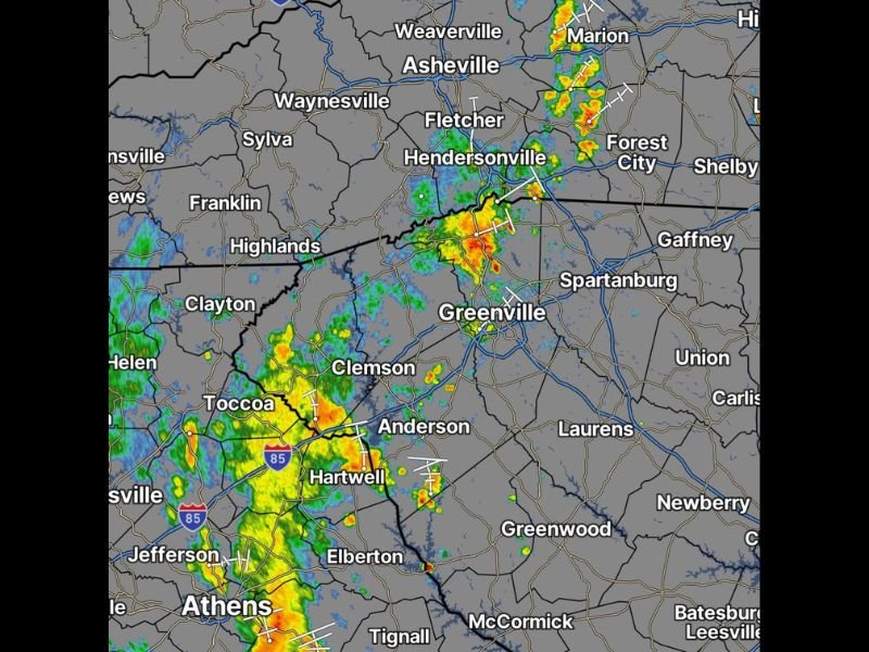
WESTERN CAROLINAS AND NORTHEAST GEORGIA — Scattered heavy rain is already moving through parts of western North Carolina, upstate South Carolina, and northeast Georgia Tuesday morning, and this on-and-off pattern will persist as a common theme throughout the entire day. Radar is showing active red and orange returns concentrated near Hendersonville, Greenville, Anderson, Toccoa, and the Athens corridor as of the morning hours, with additional cells firing across the broader mountain and foothills region.
The primary concern today is repeated rounds of heavy rainfall training over the same locations, which could lead to localized flooding where several inches of rain fall in a short period.
Active Radar Returns Already Concentrated From Hendersonville Through Greenville
The morning radar image shows the most intense activity clustered along the western Carolina and upstate South Carolina corridor from Hendersonville southward through Greenville, Clemson, Anderson, and Hartwell. Red and orange returns indicate locally heavy rainfall with the potential for rapid water accumulation in these communities during the morning hours.
Additional activity is visible near Toccoa, Athens, and the northeast Georgia corridor as the storm complex pushes southward along the I-85 corridor.
Training Storms Could Drop Several Inches in a Short Time in Some Locations
The most significant hazard Tuesday is not any individual storm but rather the potential for multiple rounds of heavy rainfall to move over the exact same communities throughout the day. When storms train over one location repeatedly, rainfall totals can accumulate to several inches within just a few hours, overwhelming drainage systems and causing localized flash flooding.
Low-lying areas, poorly drained streets, and smaller streams and creeks are the most vulnerable locations across the region today.
Temperatures Hold in the Low to Mid 70s With Dry Periods Between Rounds
Cloud cover and persistent rainfall will keep temperatures fairly steady in the low to mid 70s Tuesday, providing some comfort even as the wet and unsettled pattern continues through the day. There will be dry periods between the rounds of downpours, but most locations carry a good chance of seeing multiple storm impacts before the day ends.
Wednesday transitions back to a more typical summertime afternoon and evening thunderstorm pattern. Stay with NapervilleLocal.com for the latest weather updates and local forecast coverage.

I’ve lived in Naperville long enough to see how quickly our community changes — from new developments downtown to sudden shifts in our Midwest weather. Reporting on Naperville news and daily forecasts gives me the chance to keep neighbors informed about what really matters. My goal is simple: deliver clear, timely updates so you always know what’s happening in our city and what to expect from the skies above.