
Saturday: Mostly Sunny Skies, Elevated Brushfire Risk, and a Summer-Like Heat Wave Arriving Next Week Across Pennsylvania With Highs Potentially Nearing 90°F
HARRISBURG, Pa. — Pennsylvania is off to a beautiful start this Saturday, with mostly sunny skies taking over after a few morning clouds clear out across the state. While the day looks pleasant on the surface, drier-than-normal conditions and dropping afternoon humidity are raising an elevated brushfire risk that residents should keep in mind. Looking ahead, a powerful heat ridge building over the Eastern United States is set to deliver a taste of actual summer to the commonwealth for much of next week.
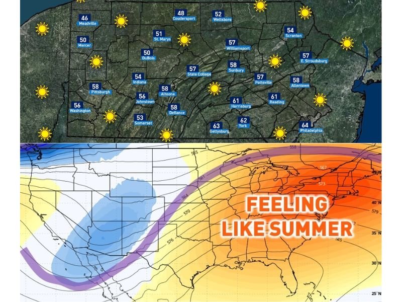
Mostly Sunny Skies to Start the Weekend
After a brief cloudy start this morning, skies will clear to mostly sunny conditions across Pennsylvania throughout the day. Temperatures on Saturday are running on the cooler side compared to what is coming next week, with readings ranging from the low 40s in the north to the mid-60s in the south and east.
Erie is sitting at just 43°F, while Meadville and Mercer are in the mid-to-upper 40s. Central areas like State College and Altoona are reaching the upper 50s, and the warmer southeastern corner of the state is seeing the best readings, with Philadelphia at 64°F, Gettysburg at 63°F, and York at 62°F.
Elevated Brushfire Risk This Afternoon
The dry stretch of weather Pennsylvania has experienced recently is combining with lower afternoon humidity to create conditions favorable for brushfires. Residents who were planning any outdoor burning today are urged to reconsider and hold off.
The risk is expected to be most elevated during the afternoon hours when humidity dips to its lowest point of the day. Even a small spark in dry vegetation could spread quickly under these conditions.
Heat Wave Building for Next Week — Peak Tuesday Through Thursday
The bigger weather story for Pennsylvania is what is arriving next week. A strong upper-level ridge settling over the Eastern United States will push temperatures well into summer territory across the state, with the peak of the heat most likely occurring Tuesday through Thursday.
Many locations are expected to climb into the 80s during that stretch, with mid-to-upper 80s looking probable across southern and southwestern Pennsylvania. Given the ongoing lack of vegetation and drier ground conditions, some spots could come close to or even touch 90 degrees.
Northern areas and higher elevations will stay somewhat cooler, while southern and eastern communities will feel the full force of the warmth — conditions reminiscent of the notable April heat that struck the region back in 2024. Stay with NapervilleLocal.com for the latest weather updates and local forecast coverage.

I’ve lived in Naperville long enough to see how quickly our community changes — from new developments downtown to sudden shifts in our Midwest weather. Reporting on Naperville news and daily forecasts gives me the chance to keep neighbors informed about what really matters. My goal is simple: deliver clear, timely updates so you always know what’s happening in our city and what to expect from the skies above.