
Saturday: Scattered Showers and Isolated Thunderstorms Possible This Afternoon Across Dallas-Fort Worth, Texas With a 30% Rain Chance
DALLAS, Texas — The atmosphere across the Dallas-Fort Worth region is showing signs of increasing moisture this Saturday afternoon, with dewpoints climbing into the mid-60s and atmospheric water content values reaching 1.25 inches per hour. That combination of available moisture and daytime heating is enough to spark scattered showers and an isolated thunderstorm or two across the broader DFW area through the afternoon hours. While the overall rain chance sits at 30%, any storm that does develop could pack a quick downpour and a rumble of thunder.
Atmosphere Charging Up With Moisture
The clearest signal that rain is possible today is the notable rise in dewpoints across the region, now sitting in the mid-60s. Dewpoints at that level indicate a fairly humid airmass for mid-April, providing the fuel that daytime heating needs to trigger shower and storm development during the warmest part of the afternoon.
Water content values in the atmosphere have also climbed to 1.25 inches per hour, meaning any shower or storm that does develop will have plenty of moisture to work with and could produce a brief but heavy downpour in a short period of time.
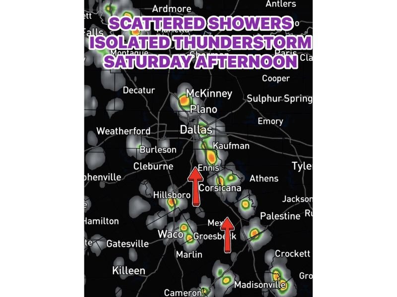
Scattered Showers and Isolated Thunderstorm Possible This Afternoon
As surface temperatures peak during the afternoon, scattered showers are expected to pop up across a wide area stretching from the northern DFW suburbs through the southern corridor toward Waco and beyond. Radar is already showing developing activity near McKinney, Plano, Ennis, Corsicana, Waco, and Groesbeck, with additional cells possible across the Hillsboro, Kaufman, and Athens areas.
An isolated thunderstorm or two cannot be ruled out, particularly where moisture pooling and daytime heating combine most favorably. These storms will be scattered in nature, meaning coverage will be uneven — some neighborhoods could see a drenching downpour while nearby areas stay completely dry.
Overall Rain Chance at 30% — But Locally Intense If It Hits
The area-wide probability of seeing measurable rain today is approximately 30%, which means the majority of locations will likely stay dry through the afternoon. However, that number should not create a false sense of security — the nature of scattered convective rainfall means that where storms do develop, they can produce a rapid and heavy downpour along with thunder in a short window of time.
Residents heading out for afternoon plans across the DFW metroplex, from Weatherford and Decatur in the west to Sulphur Springs in the east, should keep an eye on the sky and have a backup plan ready if showers develop nearby.
Storm Activity Covers a Wide North-to-South Corridor
The radar picture shows storm development spread across a broad north-to-south corridor, from the southern Oklahoma border near Ardmore down through the DFW metro and continuing south through Waco, Marlin, and toward Madisonville. The most concentrated activity on radar is visible near the Ennis-Corsicana corridor and again near the Waco-Groesbeck area, where cells are showing the highest intensity readings.
Outlying communities including Burleson, Cleburne, Hamilton, Gatesville, Killeen, and Cameron all fall within the broader zone where a passing shower remains possible through the remainder of the afternoon. Stay with NapervilleLocal.com for the latest weather updates and local forecast coverage.

I’ve lived in Naperville long enough to see how quickly our community changes — from new developments downtown to sudden shifts in our Midwest weather. Reporting on Naperville news and daily forecasts gives me the chance to keep neighbors informed about what really matters. My goal is simple: deliver clear, timely updates so you always know what’s happening in our city and what to expect from the skies above.