
Saturday: Warm Sunshine, High Fire Danger, and a Small Late-Day Storm Threat Sweep Across North Carolina With Highs Reaching the Mid-80s
RALEIGH, N.C. — North Carolina is waking up to a beautiful and rapidly warming Saturday, with partly to mostly sunny skies expected to dominate the day as temperatures climb into the 70s and low-to-mid 80s across most of the state. While conditions will feel more like May than early April, residents should be aware of elevated fire danger and a slim chance of isolated pop-up thunderstorms arriving late in the afternoon.
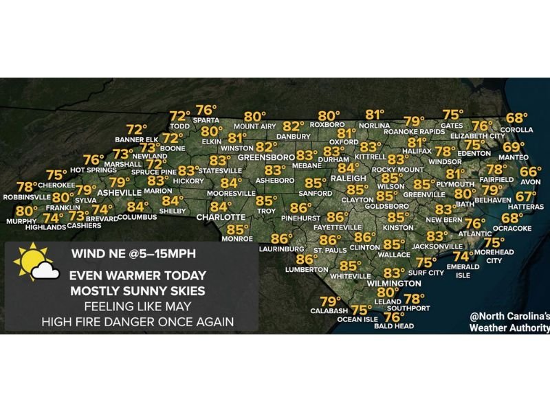
Even Warmer Today With Mostly Sunny Skies
The warmup that has been building across the Tar Heel State continues this Saturday. Most of the Piedmont and coastal plain will see highs well into the mid-80s, with cities like Charlotte, Raleigh, Fayetteville, Laurinburg, and Pinehurst all expected to top out around 84–86°F. The southern coastal areas around Lumberton and St. Pauls are also forecast to hit the mid-80s.
Cooler readings will be found in the mountains, where Banner Elk, Boone, and Newland will stay in the lower 70s. The Outer Banks and far northeast corner of the state — including Corolla, Manteo, and Ocracoke — will be milder, sitting in the upper 60s.
Northeast Winds at 5–15 MPH Add to Fire Risk
Winds will be out of the northeast at 5 to 15 mph throughout the day. While not particularly strong, these breezy conditions combined with the unseasonably warm temperatures and low humidity are enough to create high fire danger once again across the state.
Residents are urged to avoid any outdoor burning today and to be cautious with anything that could spark a fire in dry vegetation.
Slight Chance of a Late-Day Isolated Thunderstorm
It should be a mostly dry day for the vast majority of North Carolinians, but forecasters note they cannot completely rule out an isolated pop-up thunderstorm developing late in the afternoon.
Any storms that do manage to form are expected to be brief and limited in coverage — most areas will see nothing at all. This is not a widespread storm threat, but it is something to keep in mind if you are planning outdoor activities deep into the evening hours. Stay with NapervilleLocal.com for the latest weather updates and local forecast coverage.

I’ve lived in Naperville long enough to see how quickly our community changes — from new developments downtown to sudden shifts in our Midwest weather. Reporting on Naperville news and daily forecasts gives me the chance to keep neighbors informed about what really matters. My goal is simple: deliver clear, timely updates so you always know what’s happening in our city and what to expect from the skies above.