
Scattered Thunderstorms Continue Across North Carolina and Tennessee Mountains — Storms Near Boone, Asheville, and Franklin Expected Through Midnight
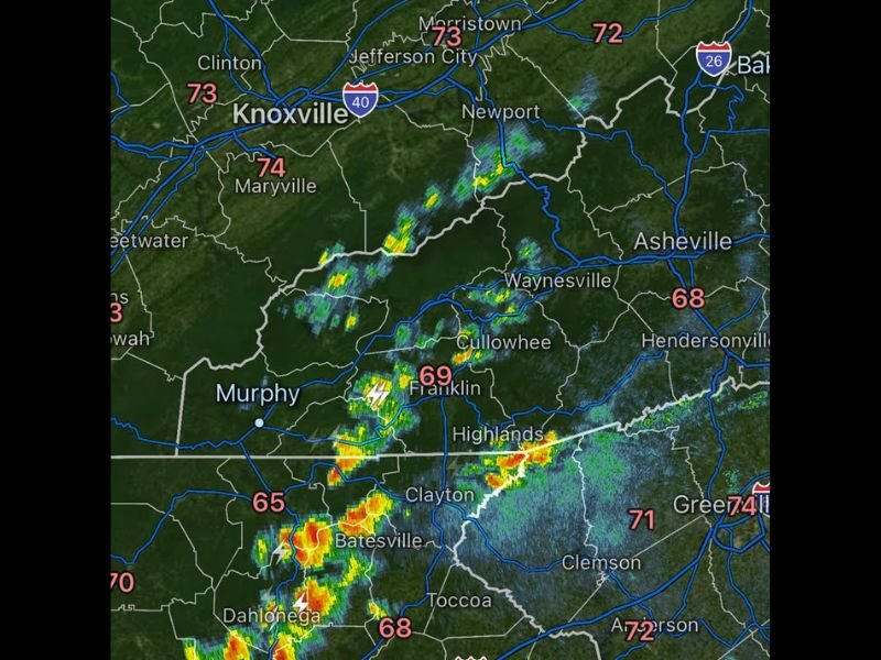
ASHEVILLE, NORTH CAROLINA — Scattered showers and thunderstorms continue to move across the mountainous regions of western North Carolina and eastern Tennessee Friday evening, with radar showing clusters of storms stretching from the Smoky Mountains to the Blue Ridge. Meteorologists say these storms could persist through about midnight as unstable conditions remain across the region’s mountains and foothills.
The storms are primarily affecting communities near Asheville, Boone, Franklin, Murphy, and Waynesville, with additional activity seen near Johnson City and Bristol along the North Carolina–Tennessee border.
Storm Clusters Moving Through the Smoky Mountains
Radar imagery shows several bands of showers and thunderstorms pushing across the Great Smoky Mountains region, including areas near Franklin, Cullowhee, and Murphy in western North Carolina.
Some storms have produced bursts of moderate rain, lightning, and brief gusty winds as they move across the rugged mountain terrain.
Temperatures across the region remain mild, generally ranging from the mid-60s to low-70s, which is helping maintain enough instability to keep thunderstorms active during the evening hours.
Thunderstorms Also Developing Near Boone and the High Country
Additional thunderstorm cells have formed farther northeast across the North Carolina High Country, particularly near Boone and Bakersville.
Lightning activity has been detected within these storms as they slowly move across the mountains toward the foothills.
While these storms are not currently classified as severe, forecasters say isolated downpours and occasional lightning strikes remain possible through the evening.
Storms Expected to Continue Into the Late Evening
Meteorologists say scattered showers and thunderstorms are expected to remain across the mountains and foothills through approximately midnight before gradually weakening overnight.
The storms are moving slowly and may redevelop at times due to lingering moisture and unstable air over the mountainous terrain.
Drivers traveling across mountain highways and rural roads may encounter brief heavy rain, wet pavement, and reduced visibility where thunderstorms pass overhead.
Mountain Weather Pattern Keeps Conditions Unsettled
Weather experts say this type of scattered storm activity is common when warm, moist air interacts with mountain terrain, helping storms redevelop throughout the evening hours.
Communities across western North Carolina and eastern Tennessee may continue to see isolated showers until conditions stabilize overnight.
Residents in mountain communities are encouraged to stay weather aware and monitor radar updates if thunderstorms continue to move through their area later tonight.

I’ve lived in Naperville long enough to see how quickly our community changes — from new developments downtown to sudden shifts in our Midwest weather. Reporting on Naperville news and daily forecasts gives me the chance to keep neighbors informed about what really matters. My goal is simple: deliver clear, timely updates so you always know what’s happening in our city and what to expect from the skies above.