
Scattered Winter System Brings Slick Travel and Light Accumulation Across Maine, New York, and New England
NORTHERN NEW ENGLAND AND UPSTATE NEW YORK — As of 6 a.m., a broad winter weather system impacting parts of Maine, New Hampshire, Vermont, Quebec, and upstate New York has become broken and scattered, a development meteorologists say was expected and is limiting overall snow and ice accumulation.
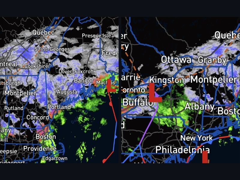
Radar imagery shows intermittent snow, light rain, and mixed precipitation spread unevenly across the region, resulting in minimal accumulation over a nearly 24-hour period, despite the system’s long duration.
Scattered Precipitation Keeping Totals Low
Forecasters note that the fragmented nature of the system is preventing heavy, continuous snowfall. Numerous breaks in precipitation are allowing road crews and surface temperatures to keep up, reducing the risk of widespread accumulation.
Cities such as Bangor, Augusta, Portland, Concord, Montpelier, Albany, Buffalo, and Ottawa are seeing on-and-off precipitation rather than steady snow, which is helping keep totals manageable.
More Moisture Still Approaching From the West
While conditions may temporarily improve in some areas, meteorologists caution that additional precipitation is still moving in from the west, meaning the system is not finished yet. Light snow or mixed precipitation could redevelop later, particularly as the low-pressure system continues to track east. This continued activity reinforces the need for patience during travel, even when radar shows temporary clearing.
Icing Mostly Controlled but Slick Spots Remain
The good news is that icing appears to be largely under control, with no widespread ice accretion indicated at this time. However, isolated slick spots remain, especially on untreated roads, bridges, and elevated surfaces. Drivers are advised to allow extra travel time and remain cautious through the day, as conditions may vary significantly over short distances.
Weather conditions will continue to evolve as the system exits the region. For continued updates on winter weather impacts and travel conditions across the U.S., visit NapervilleLocal.com, and share how conditions look where you are this morning.

I’ve lived in Naperville long enough to see how quickly our community changes — from new developments downtown to sudden shifts in our Midwest weather. Reporting on Naperville news and daily forecasts gives me the chance to keep neighbors informed about what really matters. My goal is simple: deliver clear, timely updates so you always know what’s happening in our city and what to expect from the skies above.