
Second Storm System Targets Southern Colorado and Southeast Wyoming With Mountain Snow and Rain-Snow Mix Into Saturday
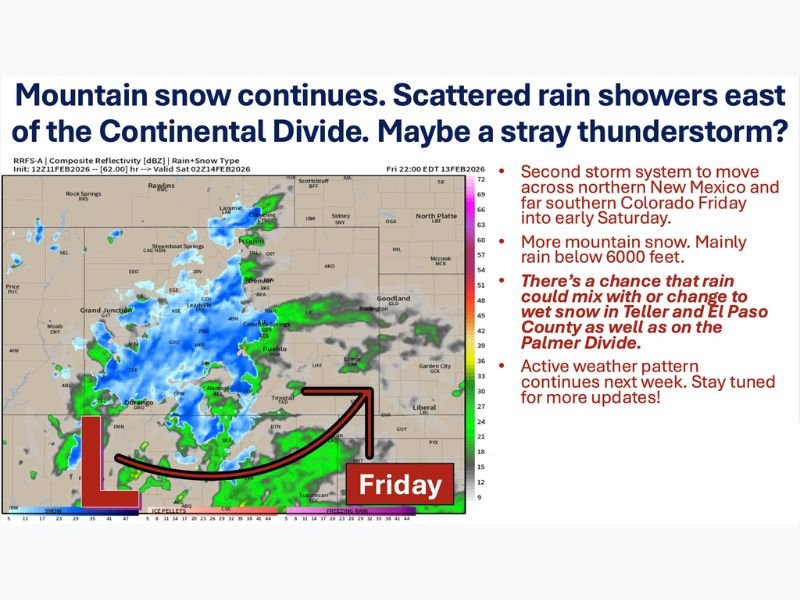
COLORADO — A second storm system is tracking out of northern New Mexico into southern Colorado Friday afternoon and night, continuing an active late-week weather pattern across the region. Mountain snow will increase again, while lower elevations east of the Continental Divide see scattered rain showers — with the potential for some areas to briefly mix with or change to wet snow by late Friday night.
Mountain snow has already been ongoing through the first half of the day, especially along and near the I-70 corridor and points north. Coverage is expected to transition into more hit-or-miss showers through the afternoon. On the Western Slope, precipitation will primarily fall as rain at lower elevations, while higher terrain continues to pick up additional snowfall.
Mountain Snow Continues, Heaviest Near and South of I-70
The current setup favors steady snow in the mountains, with another round developing as the system strengthens later Friday. Most of this round should favor areas along and south of Interstate 70, though northern mountain ranges could still see additional light accumulation into Saturday morning.
As the system matures and pushes east, snow coverage increases again over the higher terrain. Travel through mountain passes could become slick at times, especially overnight into early Saturday.
Showers East of the Divide, With Isolated Thunder Possible
East of the Continental Divide — including the foothills, portions of the I-25 corridor, the eastern plains, southeast Wyoming, and the western Nebraska Panhandle — scattered rain showers are expected through the afternoon.
There is even the possibility of a stray clap of thunder as the atmosphere destabilizes slightly. Most lower elevations should remain rain, but temperatures will be marginal enough in some areas for brief transitions late in the day.
Rain May Mix With Wet Snow in Teller and El Paso Counties
High-resolution guidance suggests that as the storm shifts into southeast Colorado and southwest Kansas Friday night, colder air could allow rain to mix with or change to wet snow at elevations as low as 6,000 to 6,500 feet.
This scenario could impact:
- Teller County
- El Paso County
- Areas along the Palmer Divide
Communities such as Woodland Park, Manitou Springs, Falcon, Peyton, Black Forest, Monument, and possibly as far north as Castle Rock and Castle Pines could see light “sneaky” accumulations late Friday night into early Saturday morning if temperatures cool just enough. Farther east across the plains and into southwest Kansas, precipitation should remain mainly rain.
Storm Wraps Up Saturday, But Active Pattern Continues
The storm system is expected to wind down Saturday night, with late Saturday through Monday trending drier across much of the region. However, this does not appear to be the end of the unsettled stretch.
Longer-range guidance indicates an active pattern could continue into next week, with the potential for additional mountain snow and continued uncertainty for lower elevations east of the Divide. As always, storm track will determine how much cold air wraps in and how widespread any snow becomes.
For now, residents in southern Colorado and nearby areas should prepare for changing conditions Friday evening and overnight — especially in higher elevations where rain-to-snow transitions are possible. Stay connected with NapervilleLocal.com for continued weather updates and detailed breakdowns as new model data becomes available.

I’ve lived in Naperville long enough to see how quickly our community changes — from new developments downtown to sudden shifts in our Midwest weather. Reporting on Naperville news and daily forecasts gives me the chance to keep neighbors informed about what really matters. My goal is simple: deliver clear, timely updates so you always know what’s happening in our city and what to expect from the skies above.