
Severe Overnight Storms Threaten Texas and Louisiana With Tornadoes, Heavy Rain, and Dangerous Winds
HOUSTON, TEXAS — A severe line of thunderstorms stretching from Houston to Lufkin and into Shreveport is intensifying overnight, prompting urgent weather alerts across parts of Texas and Louisiana. Meteorologists warn that the system is not slowing down, with several storms already showing rotation capable of producing tornadoes.
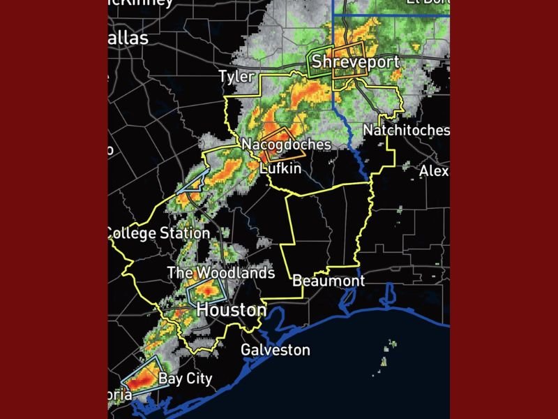
As of late Monday evening, the National Weather Service radar showed a large cluster of storms moving east toward Beaumont, Nacogdoches, and Shreveport, accompanied by lightning, damaging wind gusts, and torrential rain.
Overnight Threat and Tornado Risk
Forecasters say this system poses a significant overnight tornado risk, one of the most dangerous weather scenarios for Gulf Coast residents.
The hazards include:
- Tornado-producing supercells already embedded within the storm line
- Intense lightning and high wind gusts exceeding 60 mph
- Heavy rainfall that could lead to flash flooding
- Continued severe conditions overnight into early morning
Officials are urging residents not to underestimate the threat. “This is not the night to ignore warnings,” one meteorologist warned, adding that nighttime tornadoes are historically deadlier because people are asleep and less likely to receive alerts.
Preparedness and Safety Advice
Residents across Houston, The Woodlands, Lufkin, and Beaumont are encouraged to keep phones charged, turn on emergency alerts, and have a safe shelter plan ready.
If a tornado warning is issued, experts advise moving to an interior room on the lowest floor, away from windows and exterior walls. The Gulf Coast Weather Network humorously reminded locals to “put something on standby — shorts, sweats, a tarp, anything — and don’t be caught off guard if the sirens go off at 2 A.M.”
Storm Path and Timing
The storm line is expected to continue moving east at 45 mph, affecting East Texas through the early hours and reaching Louisiana and western Mississippi by morning.
Meteorologists warn that additional storm cells could develop ahead of the main front, creating a prolonged severe weather window lasting through dawn.
Residents are urged to stay weather-aware and prepared for sudden warnings throughout the night.
For ongoing updates and severe weather coverage across the Gulf Coast, visit NapervilleLocal.com.

I’ve lived in Naperville long enough to see how quickly our community changes — from new developments downtown to sudden shifts in our Midwest weather. Reporting on Naperville news and daily forecasts gives me the chance to keep neighbors informed about what really matters. My goal is simple: deliver clear, timely updates so you always know what’s happening in our city and what to expect from the skies above.