
Severe Overnight Storms to Sweep Across Louisiana and Mississippi Late Monday Into Tuesday, Bringing Heavy Rain and Strong Winds
LOUISIANA — Meteorologists are warning residents across Louisiana and Mississippi to prepare for a line of strong thunderstorms expected to move through the region late Monday night into early Tuesday morning, bringing heavy rain, lightning, and gusty winds.
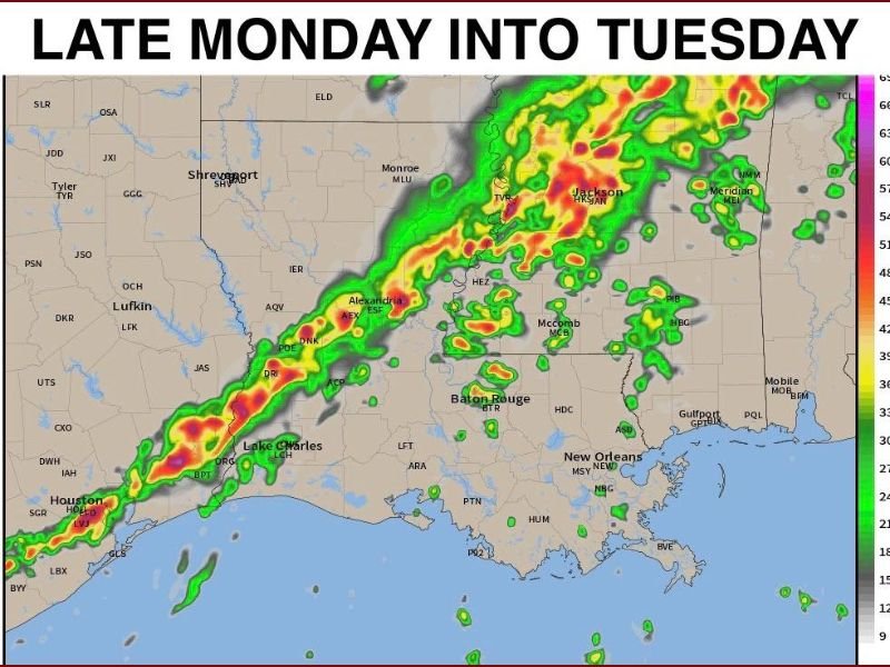
The system is forecast to intensify as it pushes eastward, forming a narrow but potent band of storms extending from Houston and Lake Charles into Jackson and Meridian, according to new model projections.
Storm Timing and Areas of Concern
The strongest activity is expected between midnight and 4 a.m., with heavy rain and strong wind gusts developing first in western Louisiana before advancing into central and northern Mississippi by daybreak Tuesday.
The National Weather Service says the most significant storm dynamics will likely concentrate across North Louisiana and Central Mississippi, but isolated thunderstorm cells may develop farther south — near Baton Rouge, Alexandria, and Lake Charles.
Forecast imagery shows the storm line producing high reflectivity values, indicating intense rainfall and potential embedded thunderstorm cores.
“Most of the energy will focus in the north, but some of these stray cells could still cause problems farther south,” meteorologists explained. “If you’re in Louisiana or Mississippi tonight, have a way to get warnings while you sleep.”
Potential Hazards
- Heavy Rain: Downpours could lead to ponding on roads and brief flash flooding in low-lying areas.
- Gusty Winds: Wind speeds may reach 40–50 mph, especially along the main squall line.
- Lightning and Isolated Thunderstorms: Some cells could intensify enough to produce hail or isolated wind damage overnight.
Drivers are urged to use caution Tuesday morning as lingering rain could impact the early commute, particularly near Jackson, Monroe, and Alexandria.
Safety Recommendations
Authorities recommend residents stay alert overnight and ensure they can receive weather alerts or warnings in real time.
- Keep mobile devices charged and enable emergency notifications.
- Avoid driving in flooded areas and secure loose outdoor items.
- Monitor regional forecasts from the National Weather Service and trusted local outlets.
Looking Ahead
Conditions should improve by Tuesday afternoon, with clearing skies and slightly cooler air moving in behind the storm front. However, forecasters caution that another system could develop later in the week as the active weather pattern continues across the Gulf South.
Stay updated with the latest forecast details and safety information at NapervilleLocal.com.

I’ve lived in Naperville long enough to see how quickly our community changes — from new developments downtown to sudden shifts in our Midwest weather. Reporting on Naperville news and daily forecasts gives me the chance to keep neighbors informed about what really matters. My goal is simple: deliver clear, timely updates so you always know what’s happening in our city and what to expect from the skies above.