
Severe Storm Chances Build From Oklahoma City to Kansas City and Toward Missouri Late This Week, With Early March Setup Worth Watching
OKLAHOMA — Storm season is beginning to stir across the southern Plains, with a late-week system bringing a low — but not zero — chance of stronger thunderstorms from Oklahoma City and Tulsa north toward Wichita and Kansas City, and east into parts of Missouri.
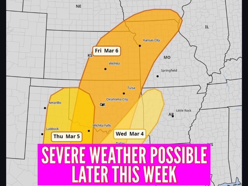
Updated risk maps show areas of concern developing in stages from Wednesday through Friday, signaling that the atmosphere is gradually becoming more supportive of springtime storms.
While this does not currently look like a major outbreak setup, a few storms could strengthen as the system moves across the region.
Wednesday: Early Signals Near Oklahoma and North Texas
By Wednesday, March 4, a highlighted risk zone extends from north Texas near Dallas into southern and central Oklahoma, including areas near Oklahoma City and Tulsa.
This appears to be the first nudge of instability returning to the region. Severe chances remain low overall, but forecasters note that early March systems can sometimes surprise if ingredients align.
Thursday: Expanding Toward West Texas and Western Oklahoma
On Thursday, March 5, the risk area broadens westward, including parts of Amarillo, Lubbock and Wichita Falls, and stretching into western Oklahoma.
This stage suggests increasing moisture and lift ahead of a larger trough pushing in from the west. Again, widespread severe weather is not expected at this time, but isolated stronger storms cannot be ruled out.
Friday: Broader Risk From Oklahoma Into Kansas and Missouri
By Friday, March 6, the highlighted area shifts north and east, covering much of Oklahoma, central and eastern Kansas, including Wichita and Kansas City, and extending into western Missouri near Springfield.
This appears to be the more organized phase of the system, with the potential for stronger thunderstorms developing as energy consolidates across the Plains and lower Midwest.
Even so, current guidance suggests:
- Severe chances remain low overall
- A few storms could become strong
- This does not look like a widespread outbreak scenario at this time
What It Means Heading Into Mid-March
It is still early March, but this pattern is a reminder that spring storm season is beginning to wake up across the Plains.
For residents in Oklahoma, Kansas and western Missouri, this is more of a “stay alert” situation than a “sound the alarms” event.
Storm season often ramps up gradually, and this setup reflects the atmosphere starting to stretch its legs.
For readers following national weather trends, including how these systems may later impact the Midwest, continue checking NapervilleLocal.com for updates as forecasts become more refined later this week.

I’ve lived in Naperville long enough to see how quickly our community changes — from new developments downtown to sudden shifts in our Midwest weather. Reporting on Naperville news and daily forecasts gives me the chance to keep neighbors informed about what really matters. My goal is simple: deliver clear, timely updates so you always know what’s happening in our city and what to expect from the skies above.