
Severe Storm Risk Across Texas and Louisiana This Saturday as Cold Front Triggers Thunderstorms and Damaging Winds
HOUSTON, TEXAS — A strong cold front is expected to move south across Texas this weekend, bringing the risk of severe thunderstorms, damaging wind gusts, and hail across portions of southeast Texas and western Louisiana by Saturday afternoon and evening.
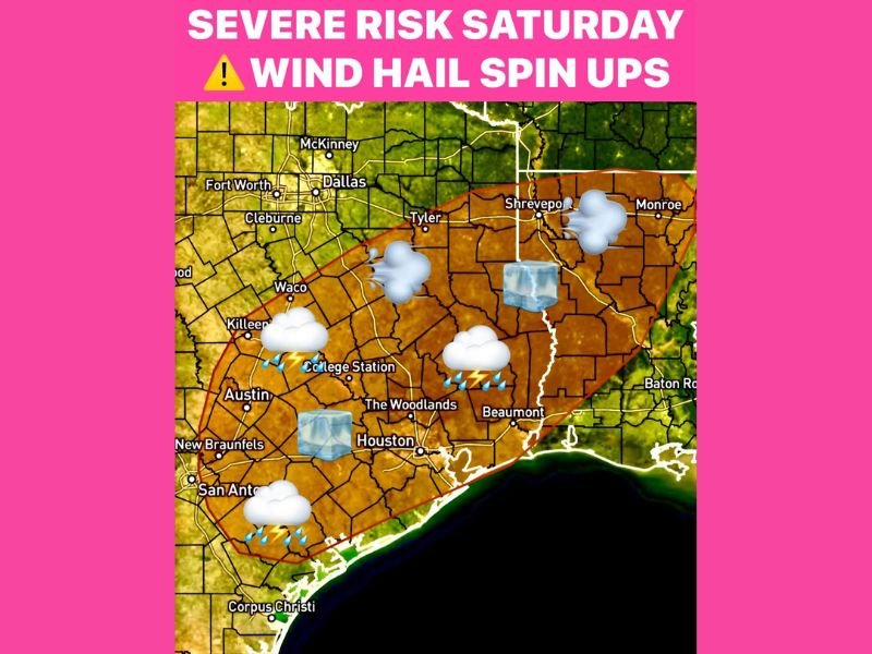
According to meteorologists, most storms will remain ordinary, but a few could turn severe, particularly across the Texas coastal plain and into western Louisiana. Areas of concern include Beaumont, Houston, College Station, Austin, San Antonio, Tyler, and Shreveport, where atmospheric conditions may favor stronger storm development.
Storm Setup and Development
Warm, humid air will surge northward ahead of the cold front, creating instability across the southern portion of the state. This energy, combined with the advancing front, will help fuel scattered thunderstorms Saturday afternoon and evening.
“The ingredients are there for a few strong to severe storms, mainly in southeast Texas and southwest Louisiana,” forecasters said. “We’re watching for pockets of damaging wind and small hail as the front approaches.”
The front’s timing will be key — storms are expected to move through quickly, with most of the activity ending after midnight as the boundary pushes into the Gulf of Mexico.
Main Weather Hazards
Meteorologists warn that while widespread severe weather is not expected, several localized hazards could develop:
- Damaging wind gusts
- Hail up to quarter size possible
- Brief spin-up tornadoes (isolated)
These conditions will be possible primarily along and east of the Interstate 35 corridor, including parts of Houston, Beaumont, and Shreveport.
“The severe threat will stay isolated, but even a few stronger storms could produce quick damage,” experts cautioned.
Areas of Highest Concern
The setup favors the southeastern Texas corridor, from San Antonio and Austin through College Station and Houston, extending eastward into Beaumont and southwestern Louisiana.
Residents in these areas should remain weather-aware and be prepared for sudden changes, particularly during the late afternoon and early evening hours when storms are most likely to intensify.
Storm Timing and Outlook
- Saturday Afternoon: Thunderstorms begin forming across central Texas
- Saturday Evening: Strongest storms expected from Houston to Shreveport
- After Midnight: Front pushes into the Gulf, ending storm activity
Following the front, much cooler and drier air will move in, bringing temperatures down into the 40s and 50s overnight with brisk north winds.
Safety Tips
Residents are encouraged to:
- Secure outdoor items and decorations ahead of strong winds.
- Stay updated with local weather alerts through the evening.
- Avoid driving during heavy rain or hail conditions.
Forecasters will continue monitoring radar and model updates for any shift in storm severity or timing.
Stay connected with NapervilleLocal.com for the latest storm coverage, weather alerts, and weekend forecast updates.

I’ve lived in Naperville long enough to see how quickly our community changes — from new developments downtown to sudden shifts in our Midwest weather. Reporting on Naperville news and daily forecasts gives me the chance to keep neighbors informed about what really matters. My goal is simple: deliver clear, timely updates so you always know what’s happening in our city and what to expect from the skies above.