
Severe Storm Risk Expands Toward Illinois and Indiana Wednesday and Friday, With Stronger Thunderstorms Possible Near Chicago
ILLINOIS — Thunderstorm chances are increasing across the Midwest starting today and continuing through the end of the week, with updated risk maps highlighting potential for a few stronger storms on both Wednesday and Friday.
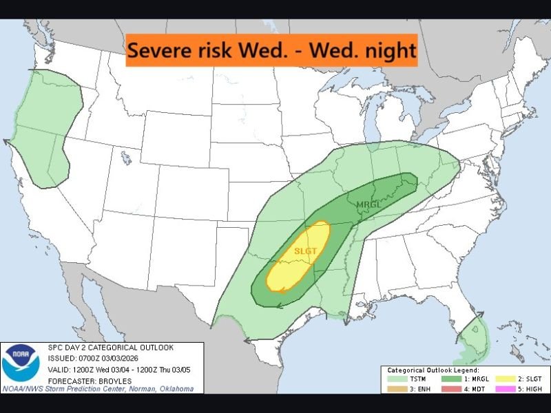
While this does not currently appear to be a widespread severe outbreak, forecasters say a handful of storms could become strong, particularly across portions of Illinois, Indiana, Missouri and surrounding states.
Wednesday Risk: Marginal to Slight Across the Midwest
The Wednesday into Wednesday night outlook shows a broad marginal risk (MRGL) stretching from the lower Mississippi Valley northeastward into the Ohio Valley and toward parts of the Great Lakes region.
Embedded within that area is a slight risk (SLGT) centered farther south, primarily across portions of Arkansas, Missouri and western Tennessee/Kentucky.
For northern Illinois — including areas near Chicago, Naperville and Aurora — the current setup suggests storms are possible, but the stronger severe parameters appear focused to the south. That said, marginal risk areas can still produce isolated strong wind gusts or small hail.
Residents across northern Illinois should monitor updates, especially if storms organize farther north than currently projected.
Friday Risk: Broader Coverage, Midwest in Focus
By Friday into Friday night, the risk area shifts and expands northward into the Midwest.
The updated map highlights a large zone of potential severe weather stretching from the southern Plains north through Missouri, Illinois, Indiana and into Michigan and Wisconsin.
Much of Illinois and Indiana fall within a highlighted zone that could support stronger thunderstorms, depending on how atmospheric ingredients align. The center of the projected higher probabilities appears over parts of Missouri and Illinois, placing northern Illinois closer to the core of the action compared to Wednesday.
While it is still several days out and details may change, Friday currently appears to hold the greater potential for stronger storms closer to the Chicago metro region.
What This Means for Naperville
For communities in and around Naperville, this pattern suggests:
- Daily thunderstorm chances beginning midweek
- A low but non-zero risk of isolated severe storms Wednesday
- A potentially higher risk window Friday into Friday night
- Strong gusty winds as the primary concern, though hail cannot be ruled out
At this time, forecasters are not signaling a high-end severe outbreak locally, but early March systems can evolve quickly.
Residents are encouraged to:
- Keep weather alerts enabled
- Review severe weather safety plans
- Stay updated as forecast confidence increases
As always, timing and storm intensity will become clearer as we get closer to each event.
For the latest severe weather updates impacting Naperville and the greater Chicago area, continue checking back with NapervilleLocal.com throughout the week.

I’ve lived in Naperville long enough to see how quickly our community changes — from new developments downtown to sudden shifts in our Midwest weather. Reporting on Naperville news and daily forecasts gives me the chance to keep neighbors informed about what really matters. My goal is simple: deliver clear, timely updates so you always know what’s happening in our city and what to expect from the skies above.