
Severe Storms Continue Across Louisiana and Mississippi Near New Orleans and Hattiesburg, Though Tornado Threat May Be Gradually Weakening
NEW ORLEANS, LOUISIANA — A large cluster of thunderstorms continued pushing across southeastern Louisiana and southern Mississippi late Tuesday night, bringing heavy rain, lightning, and localized tornado concerns across communities from New Orleans to Hattiesburg.
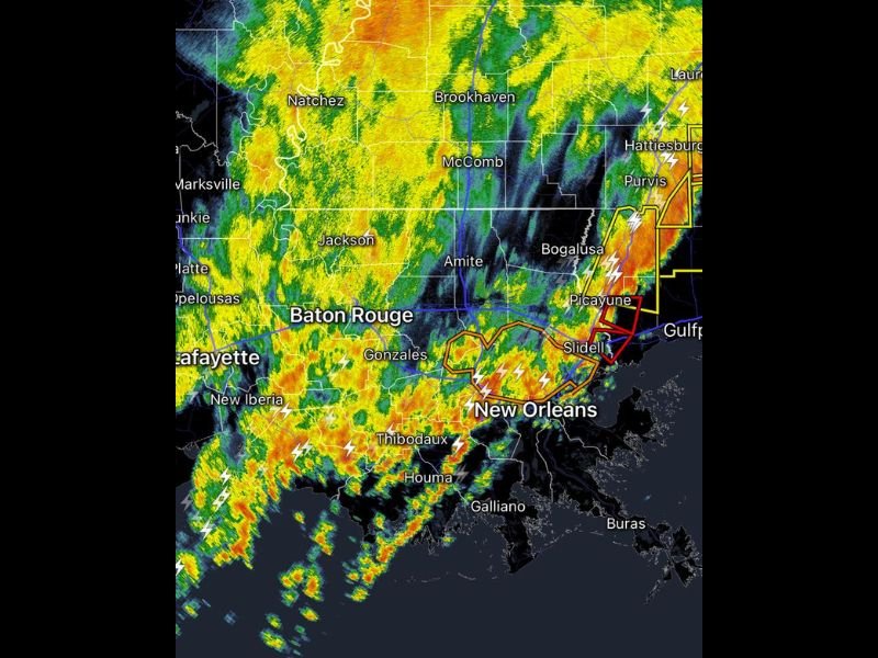
Meteorologists reviewing the latest radar data around 10:23 p.m. reported that numerous storms were still active across the region, though the most intense severe weather appears to have already occurred earlier near the Gulf Coast and along the Mississippi Northshore area.
Strong Storms Still Active Across Southeastern Louisiana
Radar imagery showed widespread storms stretching across much of southern Louisiana, with heavy rainfall and lightning concentrated around New Orleans, Baton Rouge, Lafayette, and Thibodaux.
A particularly strong line of storms was also tracking eastward near Bogalusa, Picayune, and Slidell, where tornado warnings and severe thunderstorm alerts had previously been issued earlier in the evening. These storms were producing intense rainfall bands along with frequent lightning strikes, making travel conditions hazardous across portions of the region.
Storms Moving Toward Southern Mississippi Communities
As the storm line pushed northeast, areas of southern Mississippi including Hattiesburg and Purvis were also experiencing strong thunderstorms moving through the region.
Radar signatures indicated heavy rain cores and pockets of stronger winds within the line of storms, though meteorologists suggested that the storms forming south of Lake Pontchartrain may not reach the same strength as those that previously affected the Northshore earlier in the evening.
Tornado Risk Appears to Be Gradually Decreasing
While the severe weather threat has not completely ended, forecasters say the overall tornado risk may be slowly diminishing, particularly across parts of southeastern Louisiana.
However, officials warned that quick spin-up tornadoes are still possible within the broader line of storms as it continues to move across the region. Residents in areas still under warnings should continue monitoring alerts and remain prepared to take shelter if necessary.
Heavy Rain and Lightning Continue Overnight
Even as the tornado threat gradually declines, the broader storm system is expected to continue producing heavy rain, gusty winds, and frequent lightning across parts of Louisiana and Mississippi overnight.
Cities including Bogalusa, Picayune, Hattiesburg, and surrounding communities remain within the active storm zone as the weather system slowly progresses eastward. Emergency officials are urging residents across the affected areas to remain weather-aware through the night as storms continue moving across the Gulf Coast region.

I’ve lived in Naperville long enough to see how quickly our community changes — from new developments downtown to sudden shifts in our Midwest weather. Reporting on Naperville news and daily forecasts gives me the chance to keep neighbors informed about what really matters. My goal is simple: deliver clear, timely updates so you always know what’s happening in our city and what to expect from the skies above.