
Severe Storms Expected Across Texas and Louisiana Saturday With Risks of Tornadoes, Hail, and Damaging Winds
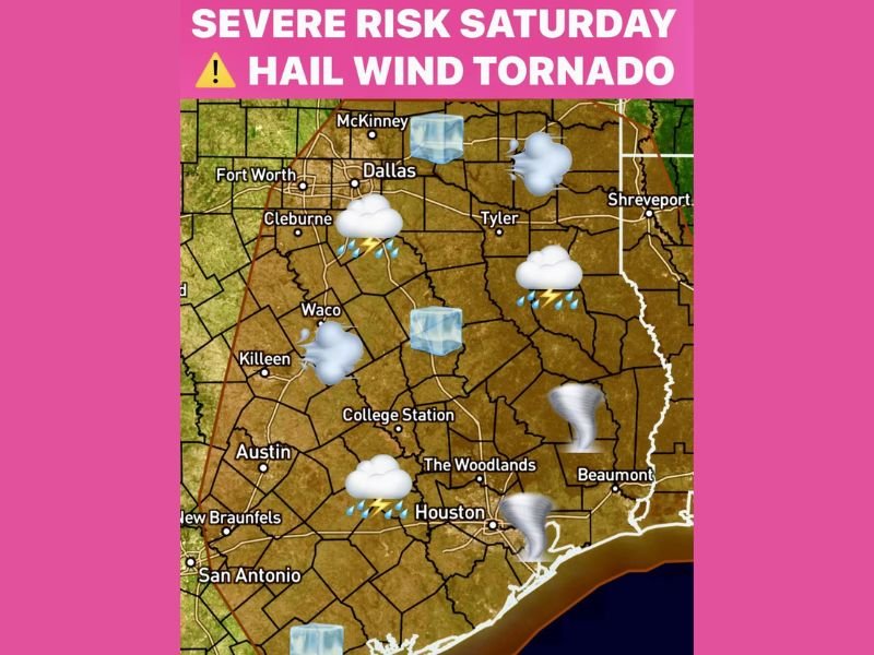
TEXAS — A strong cold front moving into the region is forecast to spark severe storms across Texas and parts of Louisiana on Saturday, with the potential for tornadoes, large hail, lightning, and damaging winds. The Storm Prediction Center (SPC) has expanded its severe weather outlook to include much of North, Central, and Southeast Texas, including major cities such as Dallas, Waco, Austin, Houston, and Beaumont.
Meteorologists expect the first line of storms to develop after 2 p.m. Saturday along the advancing front before spreading eastward through the evening.
Tornado Risk Returns for Houston and Southeast Texas
Forecasters warn that Houston and surrounding areas are once again under a tornado threat heading into Saturday evening. Increased atmospheric shear and Gulf moisture are expected to create conditions favorable for rotating thunderstorms, particularly from Houston to Lufkin and into western Louisiana.
Weather models indicate that the combination of a strong cold front, warm humid air, and upper-level energy could lead to the development of supercell storms capable of producing isolated tornadoes, especially closer to nightfall.
“This setup looks capable of producing a few tornadoes, along with large hail and wind gusts over 60 mph,” forecasters said Friday evening.
Timing and Areas Most at Risk
- 2 p.m.–5 p.m.: Storms begin forming along the cold front in North Texas, near Dallas, Fort Worth, and Waco.
- 5 p.m.–8 p.m.: The line of storms intensifies and pushes into Central and Southeast Texas, impacting Austin, College Station, and The Woodlands.
- 8 p.m.–Midnight: Severe weather threat shifts east toward Houston, Beaumont, and western Louisiana, where rotation and tornado potential increase.
Residents in the affected regions are urged to remain alert through the evening hours, as nighttime tornadoes can be particularly dangerous due to low visibility and limited warning time.
Hazards Include Hail, Strong Winds, and Lightning
Along with the tornado risk, storms could produce hail up to one inch in diameter, frequent lightning, and strong straight-line winds capable of downing trees and power lines. The SPC warns that isolated areas may experience localized flooding, especially in parts of Southeast Texas where heavy rainfall could accumulate quickly.
Travelers across Interstate 35, Interstate 45, and Interstate 10 should prepare for delays and possible detours due to rapidly changing weather conditions.
Safety Guidance From Officials
Local emergency management officials are advising residents to:
- Have multiple ways to receive weather alerts, including NOAA Weather Radio and smartphone notifications.
- Secure outdoor furniture or decorations that could be blown away by high winds.
- Avoid driving during severe thunderstorms or attempting to cross flooded roads.
- Identify a safe shelter area inside your home, such as a basement or interior room, away from windows.
Officials in Houston and Southeast Texas emphasized that the combination of evening storms and heavy traffic could pose additional hazards for those traveling during the holiday weekend.
Sunday Outlook: Cooler, Breezy Conditions
Behind the front, much cooler air will move in across Texas and Louisiana on Sunday, bringing temperatures down by 20–25 degrees. Skies are expected to clear gradually through the afternoon, though gusty north winds will persist into early Monday.
Meteorologists will continue monitoring the evolving situation, as even minor changes in temperature and wind shear could influence storm severity and track.
Stay with NapervilleLocal.com for verified weather coverage, safety updates, and official advisories as this severe weather event unfolds across Texas and Louisiana.

I’ve lived in Naperville long enough to see how quickly our community changes — from new developments downtown to sudden shifts in our Midwest weather. Reporting on Naperville news and daily forecasts gives me the chance to keep neighbors informed about what really matters. My goal is simple: deliver clear, timely updates so you always know what’s happening in our city and what to expect from the skies above.