
Severe Storms Expected Saturday from Texas to South Carolina — Damaging Winds and Hail Possible
DALLAS, TEXAS — Meteorologists are tracking a developing storm system that could bring severe thunderstorms, damaging winds, and large hail across a broad stretch of the southern United States this weekend.
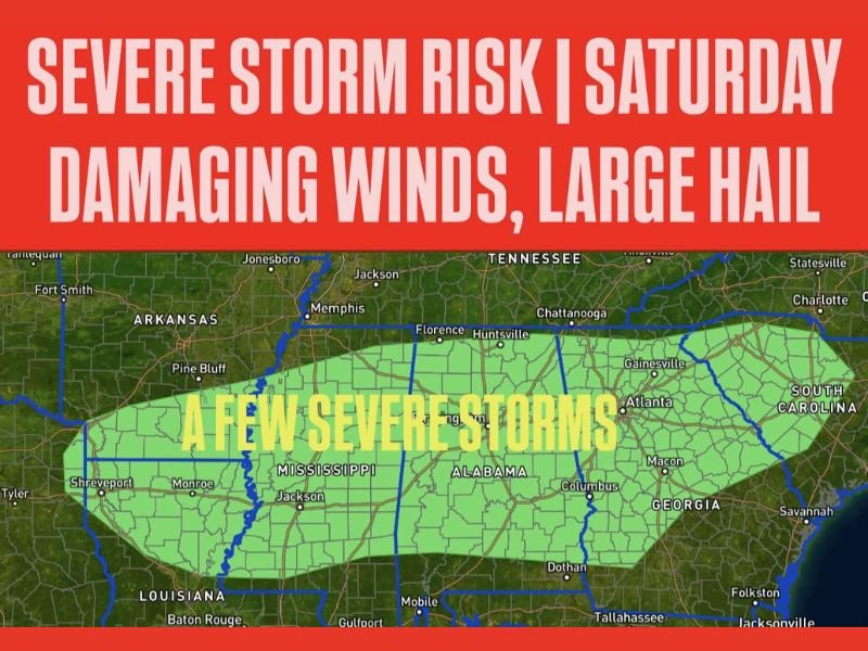
According to Meteorologist Chris Nunley, the severe weather threat will begin Saturday evening and continue into the overnight hours, impacting areas from northeast Texas to South Carolina. The main hazards expected include 60+ mph wind gusts and hail up to one inch in diameter, though isolated tornadoes cannot be fully ruled out.
Storm Risk Zone Spans Multiple States
Forecast maps show a large swath of potential storm activity extending from Shreveport, Louisiana, through Jackson, Mississippi, and Birmingham, Alabama, stretching eastward toward Atlanta, Georgia, and Greenville, South Carolina.
Nunley explained that the combination of warm Gulf moisture and a fast-moving cold front will create favorable conditions for severe thunderstorm development late Saturday.
“A few severe storms are possible Saturday evening into the overnight hours,” Nunley noted. “The main concerns are damaging wind and hail, though a brief tornado cannot be ruled out.”
Evening and Overnight Timing Raises Safety Concerns
Because many storms are expected to form and intensify after sunset, meteorologists are urging residents to ensure they have multiple ways to receive weather alerts — especially during sleeping hours.
Strong wind gusts could lead to:
- Downed tree limbs and power lines
- Scattered power outages
- Localized property damage
Meanwhile, large hail could damage vehicles, rooftops, and crops across parts of Mississippi and Alabama, where instability levels are forecast to be highest.
Forecast Breakdown by Region
- Texas and Louisiana: Initial storms are likely to develop by Saturday afternoon, bringing heavy rain and lightning before pushing eastward.
- Mississippi and Alabama: Stronger, more organized storm clusters are expected Saturday night, posing the greatest wind and hail threat.
- Georgia and South Carolina: The line of storms could reach these areas by early Sunday morning, with diminishing but still notable intensity.
What Residents Should Do
Meteorologists stress the importance of being weather-aware throughout the weekend. Residents in the risk zone should:
- Secure outdoor items such as furniture or decorations that could blow away.
- Charge devices in case of power loss.
- Park vehicles in garages or under cover to avoid hail damage.
- Review severe weather safety plans, especially for families with children or pets.
Cooler Air to Follow
Once the front passes, forecasters expect cooler and drier air to settle across the South by Sunday afternoon, ending the storm risk and bringing a brief return to calm conditions.
For live updates, forecast changes, and safety tips during severe weather, visit NapervilleLocal.com for the latest regional reports.

I’ve lived in Naperville long enough to see how quickly our community changes — from new developments downtown to sudden shifts in our Midwest weather. Reporting on Naperville news and daily forecasts gives me the chance to keep neighbors informed about what really matters. My goal is simple: deliver clear, timely updates so you always know what’s happening in our city and what to expect from the skies above.