
Severe Thunderstorm Watch Issued for Large Parts of West and Central Texas With Tornado and Hail Threat Until 10 PM
TEXAS — The National Weather Service (NWS) has placed large portions of West and Central Texas under a Severe Thunderstorm Watch until 10 PM CST, warning residents to prepare for potentially dangerous conditions including tornadoes, large hail, and damaging winds.
Strong Storms Targeting the Region
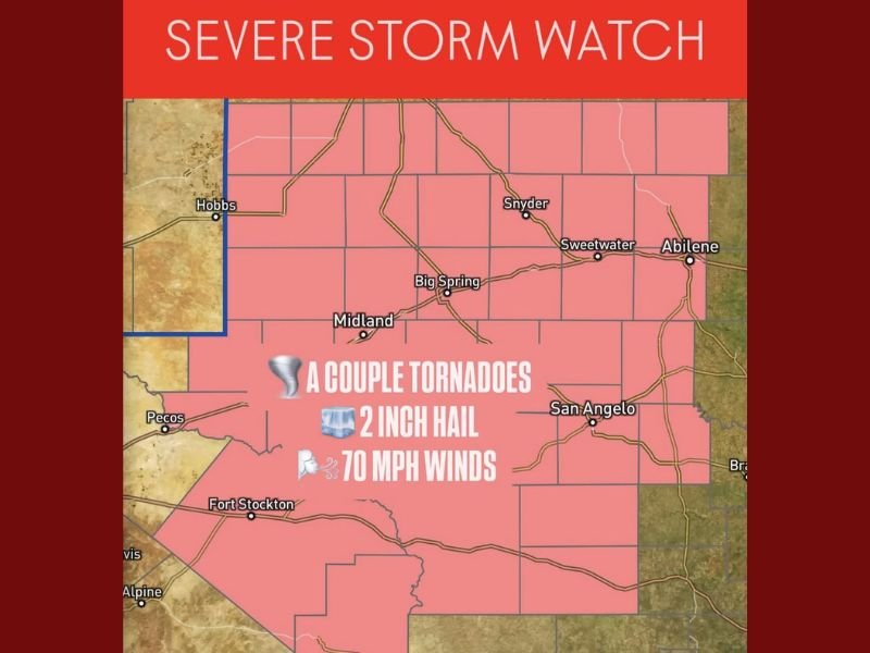
Meteorologists say storms have rapidly intensified this evening across the Permian Basin and Big Country regions, affecting areas such as Midland, Big Spring, San Angelo, Abilene, and Sweetwater. The storm line extends westward toward Fort Stockton and Pecos, where radar imagery shows strengthening supercells capable of producing rotating updrafts.
According to the NWS, the watch area faces multiple hazards, including:
- A couple of tornadoes possible
- Hail up to 2 inches in diameter
- Wind gusts up to 70 mph
These conditions are being fueled by warm, unstable air moving in from the Gulf and a cold front pushing across the Texas plains — a combination that often leads to severe thunderstorm development.
Timing and Areas of Concern
Storm activity is expected to continue into the late evening, with the strongest storms occurring between 6 PM and 10 PM. Areas east of Midland and San Angelo could experience hail-producing storms that later merge into a squall line, increasing wind damage potential overnight.
Residents in Abilene, Snyder, and Sweetwater are urged to stay weather-aware as new warnings could be issued quickly.
“These storms may evolve into clusters capable of producing significant wind damage,” forecasters at the NWS warned. “Be prepared to take cover immediately if a warning is issued.”
Preparedness and Safety Tips
Authorities advise residents in the affected zones to:
- Secure outdoor items that could blow away in high winds.
- Avoid driving through flooded roadways or during active severe storms.
- Move vehicles indoors to prevent hail damage.
- Keep a NOAA Weather Radio or emergency alert system active throughout the evening.
Looking Ahead
Forecasters note that after the storms move eastward, North and East Texas could see scattered strong storms into early Tuesday morning. The risk for localized flooding also remains where heavy rain repeatedly falls over the same areas.
Stay tuned for continued updates from the National Weather Service and reliable coverage here at NapervilleLocal.com, where we’ll track the latest developments and safety advisories as this severe weather event unfolds.

I’ve lived in Naperville long enough to see how quickly our community changes — from new developments downtown to sudden shifts in our Midwest weather. Reporting on Naperville news and daily forecasts gives me the chance to keep neighbors informed about what really matters. My goal is simple: deliver clear, timely updates so you always know what’s happening in our city and what to expect from the skies above.