
Severe Tornado Threat Forecasted for Parts of Texas, Louisiana, and Arkansas on Monday
TEXAS — Weather experts are warning residents across eastern Texas, northwestern Louisiana, and southwest Arkansas to prepare for a potentially dangerous outbreak of severe thunderstorms and tornadoes on Monday, with the strongest storms expected in central and eastern Texas.
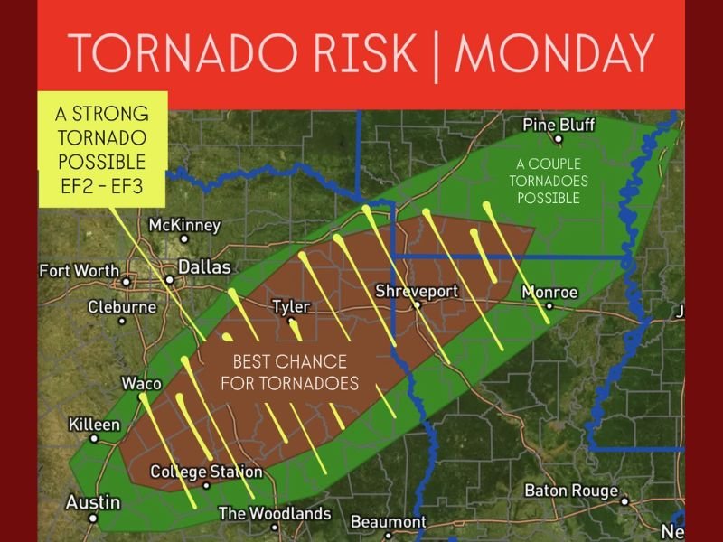
High Tornado Risk Across the Region
According to the latest forecast maps, a strong tornado threat (EF2–EF3 range) will extend from just east of Austin and College Station, stretching through Tyler and Shreveport, and up toward southern Arkansas. Meteorologists say this corridor has the best chance for tornado development, with damaging winds and large hail also possible.
The Brazos Valley, East Texas Piney Woods, and nearby communities fall directly under the most significant risk area. Forecasters are urging anyone living or traveling through these zones to remain alert, as conditions may deteriorate quickly throughout the day.
Weather Service Guidance
The National Weather Service and independent meteorologists stress that this setup could produce a couple of strong tornadoes, especially where warm, moist air from the Gulf collides with cooler air sweeping in from the west.
Residents are advised to keep multiple ways to receive weather warnings, including NOAA radios and mobile alerts, and to review emergency plans in advance of Monday’s storms.
“If you live in or are traveling through central or eastern Texas, know where you’ll go if a tornado warning is issued,” forecasters cautioned.
Preparedness and Safety
Communities in Waco, Tyler, Shreveport, and College Station are advised to monitor the forecast closely and secure outdoor items that could become projectiles in strong winds. Those in manufactured homes or vehicles should identify nearby sturdy shelters ahead of time.
Emergency management officials recommend residents:
- Avoid travel during active warnings
- Move to an interior room on the lowest floor of a sturdy building
- Keep phones charged and flashlights ready in case of power outages
Next System Movement
As the storm system progresses eastward into Louisiana and Arkansas, the severe risk may continue into the evening hours. Areas near Monroe and Pine Bluff may see a couple of isolated tornadoes by late Monday.
Meteorologists say the setup is typical for late November but emphasize that localized severe weather can develop rapidly.
Stay tuned to official sources such as the National Weather Service and local news outlets for real-time updates.
For continuing weather coverage and preparedness tips, visit NapervilleLocal.com.

I’ve lived in Naperville long enough to see how quickly our community changes — from new developments downtown to sudden shifts in our Midwest weather. Reporting on Naperville news and daily forecasts gives me the chance to keep neighbors informed about what really matters. My goal is simple: deliver clear, timely updates so you always know what’s happening in our city and what to expect from the skies above.