
Severe Weather Likely South of Chicago Tuesday Night as Kankakee and LaSalle Face Higher Risk While Naperville May See Rain and Thunder
CHICAGO AREA, ILLINOIS — The latest forecast update suggests that while strong storms are expected across parts of Illinois Tuesday night, the most dangerous severe weather may remain south of the Chicago metropolitan area, potentially sparing communities like Naperville from the worst impacts.
New forecast data arriving Sunday evening indicates that the most intense supercell development could track across areas south of Chicagoland, while cooler, more stable air coming off Lake Michigan may help limit the severe threat closer to the lake and northern suburbs.
Severe Storm Corridor Expected South of Chicagoland
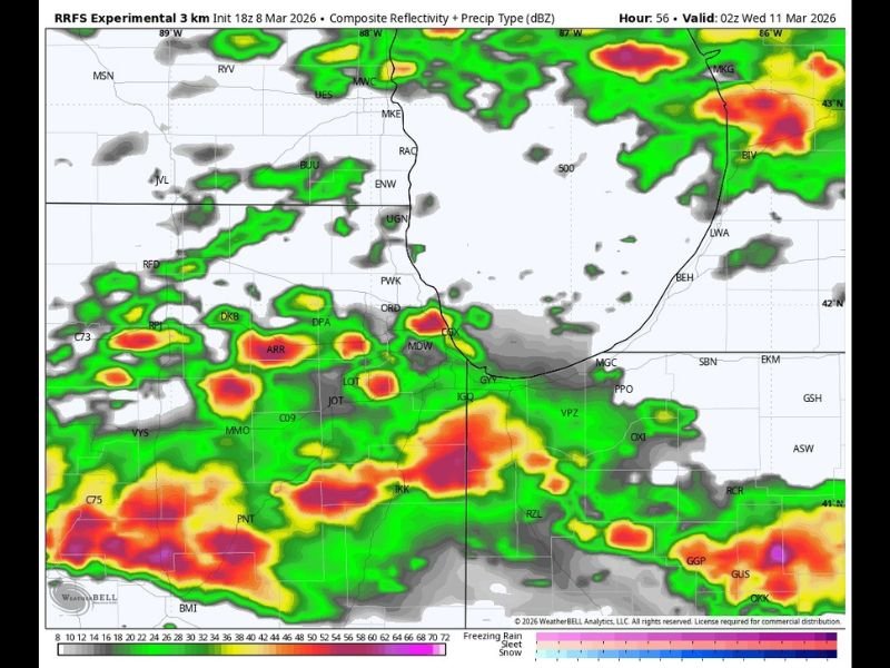
Forecast guidance currently points to the highest severe weather risk developing south of Chicago, where atmospheric conditions will likely be more favorable for organized thunderstorms. Communities including Kankakee and LaSalle are among the areas that could face a greater risk if storms intensify late Tuesday.
Meteorologists monitoring the setup say that storms forming in southern portions of Illinois may organize into stronger supercells as they move east or northeast across the region. While the exact track of the storms remains uncertain, areas farther south appear more likely to experience the strongest weather conditions.
Naperville and Northern Suburbs May Stay on the Edge of the Threat
For the Naperville and greater Chicago area, the current forecast suggests a lower risk of severe weather compared with locations farther south.
One key factor is cool, stable air flowing inland from Lake Michigan, which can sometimes limit storm intensity near the lakeshore and across northern suburbs.
Because of this influence, the Chicago metro region may mainly experience general rain showers and thunderstorms Tuesday night, rather than the most dangerous severe storms.
However, forecasters caution that storm tracks can shift, and even small changes in atmospheric conditions could bring stronger storms farther north.
Forecast Models Show Storms Developing South of Interstate 80
Weather model simulations indicate storms developing primarily across southern sections of northern Illinois, with the most active storm clusters tracking south of the Interstate 80 corridor.
Areas south of this zone could see stronger storms with heavier rainfall and lightning, while regions farther north may experience more scattered thunderstorm activity. Cities like Kankakee and LaSalle remain locations to watch closely if storm development intensifies late Tuesday.
Meteorologists Continue Monitoring the Setup
While early model runs show the strongest severe weather remaining south of Chicago, meteorologists emphasize that forecast data can still shift over the next 24 to 48 hours.
Even a small northward adjustment in the storm track could bring stronger storms closer to the Chicago metro area.
For now, the expectation is that the Chicago region—including Naperville—will likely see rain and thunderstorms Tuesday night, while the highest severe weather potential remains farther south across Illinois.
Residents across northern Illinois are encouraged to monitor forecast updates as meteorologists continue analyzing incoming weather data ahead of the approaching storm system.

I’ve lived in Naperville long enough to see how quickly our community changes — from new developments downtown to sudden shifts in our Midwest weather. Reporting on Naperville news and daily forecasts gives me the chance to keep neighbors informed about what really matters. My goal is simple: deliver clear, timely updates so you always know what’s happening in our city and what to expect from the skies above.