
Severe Weather Threat Builds Across Texas, Oklahoma, and Arkansas Midweek as Powerful Pacific Storm Approaches
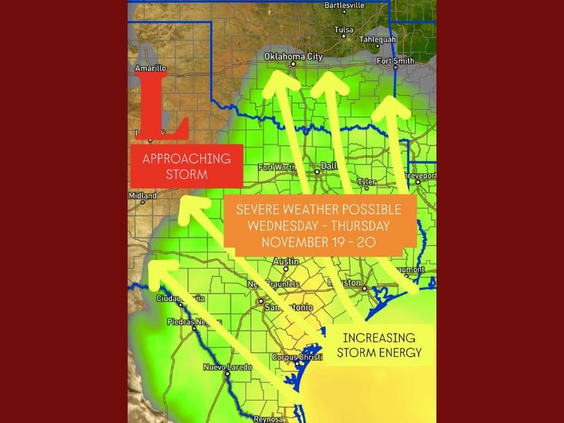
DALLAS, Texas — A powerful Pacific storm system is expected to move into the Southern Plains by Wednesday and Thursday (Nov. 19–20), bringing the first widespread threat of severe weather this month across Texas, Oklahoma, and Arkansas, forecasters warn.
According to early model data, the system will pull in warm, moisture-rich air from the Gulf of Mexico while a strong jet stream provides the lift and wind shear needed to fuel intense thunderstorms. Meteorologists say all modes of severe weather — including heavy rain, hail, strong winds, and isolated tornadoes — will be possible across the region.
Storm Energy Building Across Texas and Oklahoma
The approaching Pacific low-pressure system is already increasing “storm energy” across Texas and Oklahoma, creating unstable atmospheric conditions conducive to thunderstorm development.
“This setup has the potential to bring widespread strong-to-severe storms as the system sweeps east midweek,” forecasters said. “Moisture inflow from the Gulf combined with upper-level dynamics will increase instability and shear, leading to a potentially active weather pattern.”
Computer models currently show the highest risk zone stretching from Central and North Texas into southeastern Oklahoma and parts of western Arkansas. Cities including Dallas, Fort Worth, Oklahoma City, and Little Rock could all experience periods of intense thunderstorms and localized flooding.
Timing and Expected Impacts
- Monday–Tuesday (Nov. 18–19):
Isolated storms may begin developing across the Ozarks and eastern Texas, but activity should remain scattered. - Wednesday–Thursday (Nov. 19–20):
The main cold front associated with the Pacific system moves through Texas, Oklahoma, and Arkansas, increasing the risk for widespread severe storms. Forecasters say this period will bring the highest likelihood of damaging winds and hail. - Friday (Nov. 21):
The storm system pushes east, with additional rain possible across Louisiana, Mississippi, and Tennessee before conditions gradually clear by the weekend.
Meteorologists emphasize that the exact timing and strength of the storms may shift as the system develops, but current trends suggest an active and potentially dangerous pattern for much of the Southern Plains.
Heavy Rain and Flash Flooding Potential
Along with the threat for severe thunderstorms, this storm system could bring heavy rainfall totals of 2–4 inches in some areas, especially across eastern Texas and southern Arkansas. The National Weather Service cautions that urban flooding and swollen creeks are possible in low-lying regions.
“Ground conditions in many areas are already saturated, so flash flooding could develop quickly,” one forecaster noted.
Possible Tornado Risk
While widespread tornado activity is not yet certain, forecasters say the combination of warm Gulf air and strong wind shear could allow for a few isolated tornadoes, particularly in east and northeast Texas on Wednesday night.
“This is a dynamic setup — and while it’s too early to pinpoint exact locations, the risk for rotating storms will increase as the front approaches,” meteorologists added.
Residents in Fort Worth, Dallas, Tyler, and Shreveport should stay alert for updated weather statements and potential severe thunderstorm watches or warnings issued later this week.
Another Storm System on the Horizon
Following the midweek outbreak, a secondary Pacific storm may approach the Southern Plains by late next weekend, potentially bringing renewed rain and thunderstorm chances into the start of Thanksgiving week.
Early outlooks suggest this could bring another round of unsettled weather stretching from Texas to the Midwest.
Safety and Preparedness Tips
Officials urge residents to:
- Review emergency weather plans and ensure cell phone alerts are enabled.
- Avoid driving during periods of intense rainfall or when flash flooding occurs.
- Secure outdoor objects ahead of strong winds.
- Keep flashlights and backup power supplies ready in case of outages.
As models continue to refine, meteorologists will provide updated forecasts throughout the week to help communities prepare for what could be one of the strongest storm events of November.
Do you live in one of the areas expected to be affected by this midweek storm system? Stay informed and share local conditions with us at NapervilleLocal.com as the weather pattern evolves.

I’ve lived in Naperville long enough to see how quickly our community changes — from new developments downtown to sudden shifts in our Midwest weather. Reporting on Naperville news and daily forecasts gives me the chance to keep neighbors informed about what really matters. My goal is simple: deliver clear, timely updates so you always know what’s happening in our city and what to expect from the skies above.