
Severe Weather Threat Builds for Texas, Arkansas, Louisiana, and Mississippi Next Week as Strong Storm System Develops
TEXAS — A potentially dangerous weather pattern is developing for Texas, Arkansas, Louisiana, and Mississippi next week, as forecast models show signs of a strong storm system capable of producing damaging winds, heavy rainfall, and possible tornadoes.
Forecasters are closely monitoring model data suggesting that this setup could form during the middle of next week, marking one of the most significant severe weather risks for the South this November.
Forecast Models Indicate Strong System Forming Over the South
Meteorologists say that the upcoming system could start in eastern Texas before tracking eastward through Arkansas, Louisiana, and Mississippi, bringing a multi-day threat of severe storms.
“While details are still being refined, the pattern suggests potential for all types of severe weather,” forecasters said. “This includes strong winds, hail, and even isolated tornadoes.”
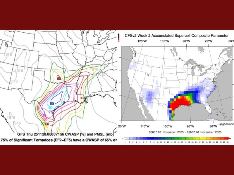
Long-range forecast guidance — including the GFS and CFSv2 weather models — shows a strong cluster of instability across east Texas late next Wednesday night, with conditions favorable for rotating storms and organized squall lines to form as the system moves east.
Meteorologists Warn of Elevated Tornado and Wind Risk
One key indicator raising concern is the Composite Supercell Parameter, a measure used to evaluate the potential for intense thunderstorm development.
According to the data, elevated values are appearing across eastern Texas and western Louisiana, signaling that the atmosphere could be primed for supercell storms — the type most capable of producing tornadoes.
“This kind of setup has a history of producing significant severe weather outbreaks across the South,” meteorologists explained. “Given the strength of the upper-level energy and Gulf moisture return, the threat for damaging winds and tornadoes appears elevated.”
Timing the Storm System’s Progression
The system is expected to unfold in stages, beginning in Texas around midweek, then shifting eastward toward the lower Mississippi Valley:
- Tuesday–Wednesday (Nov. 19–20): Storms begin to form across central and eastern Texas, potentially intensifying by evening.
- Wednesday night–Thursday (Nov. 20–21): The strongest storms move into Louisiana and Arkansas, bringing heavy rainfall, lightning, and strong winds.
- Thursday–Friday (Nov. 21–22): The line of storms could extend into Mississippi and western Alabama, maintaining the risk for severe weather.
While the models continue to evolve, early signals show the highest impact zone from Houston and Shreveport through Little Rock and Jackson, areas familiar with late fall severe weather outbreaks.
Atmospheric Conditions Setting the Stage
The setup for this potential outbreak is driven by a combination of:
- Warm, humid air flowing north from the Gulf of Mexico.
- A strong jet stream sweeping across the southern states.
- An advancing cold front creating the instability needed for thunderstorm formation.
These ingredients together create a volatile environment capable of producing intense updrafts, rotation, and lightning, especially during evening hours when temperatures begin to drop.
The CFSv2 model, which measures the Accumulated Supercell Composite Parameter, highlights a red and orange band stretching from Texas through Mississippi, indicating elevated thunderstorm energy levels.
Residents Urged to Monitor Updates Closely
Meteorologists stress that this forecast is still in the early modeling phase and may shift as the event approaches. However, they’re urging residents across the South to remain alert, especially those with travel or outdoor plans next week.
“Confidence is growing that a strong system will develop,” one forecaster said. “If the Gulf moisture return verifies, the potential for widespread storms and tornadoes will be significant.”
Local emergency managers advise that residents review safety plans, ensure their weather alerts are active, and keep flashlights and batteries ready in case of power outages.
Looking Ahead: What Comes After the Storms
Once the storm system passes, meteorologists expect a sharp drop in temperatures across the same southern states. The arrival of cooler, drier air behind the front could mark the start of a larger pattern shift leading into Thanksgiving week — possibly connecting to the broader Arctic air outbreak already being tracked for the end of November.
For now, forecasters stress that model guidance remains subject to change, but early signs suggest a notable severe weather event may unfold across multiple southern states next week.
Do you think this November’s severe storm setup could mirror spring weather patterns? Share your thoughts and follow more national weather updates at NapervilleLocal.com.

I’ve lived in Naperville long enough to see how quickly our community changes — from new developments downtown to sudden shifts in our Midwest weather. Reporting on Naperville news and daily forecasts gives me the chance to keep neighbors informed about what really matters. My goal is simple: deliver clear, timely updates so you always know what’s happening in our city and what to expect from the skies above.