
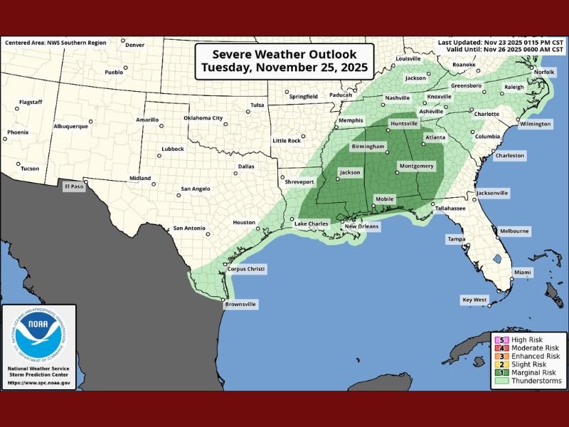
Severe Weather Threat Expands Across the Gulf States and Florida on Tuesday
GULF COAST — Forecasters are monitoring a broad severe weather threat set to impact parts of the Gulf Coast, Deep South, and Florida Panhandle on Tuesday, November 25, 2025. The system could bring strong thunderstorms, heavy rainfall, and isolated tornadoes, lasting through Tuesday night into early Wednesday.
Storm Threat Expands Eastward
According to the NOAA Storm Prediction Center, the severe weather outlook now stretches from eastern Texas through Louisiana, Mississippi, Alabama, and Georgia, extending into the Florida Panhandle. Meteorologists have increased storm probabilities, warning that atmospheric instability and moisture from the Gulf of Mexico will fuel the development of strong to severe storms.
The highest risk areas currently include southern Mississippi, central Alabama, and parts of western Georgia, where forecasters say gusty winds, heavy rain, and isolated tornadoes are most likely.
Timing and Key Impacts
- Tuesday Afternoon to Night: Thunderstorms expected to form along a cold front advancing eastward.
- Evening through Overnight: Storms intensify as they move across the Gulf states and into northern Florida, with the potential to last into early Wednesday morning.
- Primary threats: Damaging winds, frequent lightning, localized flooding, and a few tornadoes, especially in regions highlighted under “Slight Risk” zones.
Areas to Watch
Cities such as Birmingham, Montgomery, Mobile, Jackson, and New Orleans are in the forecast path, while the Atlanta metro area and Florida Panhandle could experience storm activity later in the day.
“Storm chances have been bumped up and now extend more across the upper Gulf into Florida. It’s something to keep a close watch on as conditions evolve,” weather analysts at SpaghettiModels.com noted.
Preparedness Tips
Residents in affected areas are urged to:
- Keep weather radios or alert apps active overnight.
- Avoid driving through flooded roadways.
- Secure outdoor items that may blow away in strong gusts.
- Review shelter plans in case of tornado warnings.
Meteorologists will continue to monitor changes in atmospheric conditions and update local forecasts as new model data becomes available.
Stay updated with reliable sources such as the National Weather Service and NapervilleLocal.com for real-time alerts and safety guidance.

I’ve lived in Naperville long enough to see how quickly our community changes — from new developments downtown to sudden shifts in our Midwest weather. Reporting on Naperville news and daily forecasts gives me the chance to keep neighbors informed about what really matters. My goal is simple: deliver clear, timely updates so you always know what’s happening in our city and what to expect from the skies above.