
Sharp Snow Band to Sweep From Illinois Through Indiana, Ohio, and Into West Virginia as Fast-Moving Clipper Drops 2–4 Inches and Creates Travel Delays
Illinois — A fast-moving Alberta clipper system is forecast to deliver a narrow but impactful 2 to 4-inch snow band stretching from Illinois across Indiana and Ohio and into West Virginia, beginning Thursday night and continuing through Friday. Model guidance indicates that a few isolated areas may see up to 5 inches where the heaviest part of the band settles, raising concerns for slick roads, reduced visibility, and early-morning travel disruptions across multiple states.
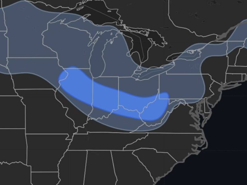
A Narrow but Potent Snow Stripe Expected From the Midwest to Appalachia
The forecast snow map shows a well-defined stripe of accumulating snow beginning in central and eastern Illinois, then extending eastward across Indiana, southern portions of Ohio, and into West Virginia. While the system is not large in size, meteorologists emphasize that its sharp intensity and quick movement will make it capable of producing abrupt changes in driving conditions.
Interstates I-74 and I-70 appear to be the primary corridors affected, with snowfall likely to accumulate on untreated surfaces. With temperatures staying near or below freezing in many areas, even modest snowfall totals can create hazardous travel conditions.
Short-Duration System With Quick Impacts
This clipper will move quickly, but its efficiency at producing snow within a narrow zone makes it a concern for both commuters and freight transportation. Forecasters warn that the snow may begin suddenly, leading to rapidly deteriorating pavement conditions. The heaviest snowfall is expected to occur overnight into Friday morning, coinciding with peak travel times in parts of Illinois, Indiana, and Ohio.
Because clippers often bring dry, powdery snow, blowing and drifting may also occur in exposed areas, further impairing visibility.
Why This Clipper Is More Noticeable Than Typical Early-Season Events
Despite being a smaller system, the clipper stands out because of its concentrated snow band, which can deliver localized but impactful accumulation along its path. The lower-level jet pattern is aligned in a way that supports banded snowfall, meaning residents directly under the stripe may experience consistent, steady snow even as nearby areas receive much lighter amounts.
This setup increases the likelihood of isolated 5-inch pockets, especially across central Indiana and southern Ohio, depending on where the band ultimately stabilizes.
What Residents Should Prepare For
Drivers should expect slippery roads, particularly before sunrise Friday. Municipal crews may need to respond quickly to changing conditions, especially on bridges and untreated secondary roads. Residents along the I-74 and I-70 corridors should monitor updated snowfall projections and plan for extra commute time Friday morning.
For continued updates on snow forecasts and regional weather impacts, visit NapervilleLocal.com for the latest coverage.

I’ve lived in Naperville long enough to see how quickly our community changes — from new developments downtown to sudden shifts in our Midwest weather. Reporting on Naperville news and daily forecasts gives me the chance to keep neighbors informed about what really matters. My goal is simple: deliver clear, timely updates so you always know what’s happening in our city and what to expect from the skies above.