
Sharp Temperature Drop to Hit Florida on Friday as Jacksonville, Orlando, Tampa And Ocala Brace for Frost and the Coldest Morning of the Season
Florida — A sharp temperature drop is expected across the state Friday morning, bringing the coldest conditions of the season to large portions of northern and central Florida. Forecast maps show widespread lows falling into the 30s and low 40s, with frost possible from Ocala northward through the Panhandle. Even major metro areas such as Jacksonville, Orlando, Tampa, Fort Myers, and Miami will see temperatures well below seasonal averages.
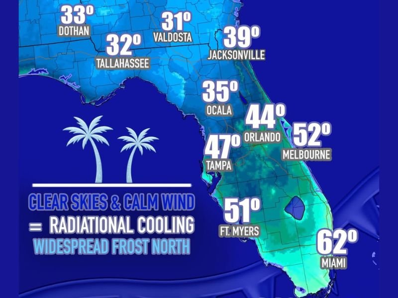
Coldest Morning of the Season Expected Across Northern and Central Florida
According to the updated forecast, several locations in northern Florida will start Friday with temperatures near or below freezing. Projected lows include 31°F in Valdosta, 32°F in Tallahassee, and 33°F in Dothan, while Ocala is expected to drop to around 35°F. Jacksonville is forecast at 39°F, marking a significant departure from average December temperatures.
Central Florida is also set to cool sharply, with Orlando forecast at 44°F and Melbourne at 52°F. Farther south, temperatures become less extreme but still notably cooler, with Tampa at 47°F, Fort Myers at 51°F, Miami at 62°F, and Key West at 68°F. These values indicate a statewide cool-down, with northern counties facing the most impactful cold.
Ideal Conditions for Frost Formation in the Northern Counties
Meteorologists note that clear skies and calm winds — both present Friday morning — will enhance radiational cooling, allowing temperatures to fall quickly overnight. These conditions increase the potential for widespread frost in areas north of Ocala, especially in rural and low-lying regions.
Frost may create hazards for agriculture, landscaping, and sensitive vegetation. Residents are advised to take precautions to protect plants, cover exposed pipes where necessary, and ensure pets remain indoors during the coldest hours of the morning.
Cold Air Reaches as Far South as Miami and Key West
While frost concerns remain centered in the northern counties, the cold surge will extend deep into the peninsula. Miami is forecast to drop into the low 60s, and Key West will fall into the upper 60s — unusually cool values for early December in South Florida.
The broader temperature spread suggests a statewide response to a strong high-pressure system moving through the Southeast, allowing cooler, drier air to settle over Florida.
What Residents Should Expect Friday Morning
Residents should prepare for a colder-than-normal start to the day, with temperatures at their lowest shortly after sunrise. Drivers may encounter isolated patches of frost in northern counties, and those with early travel plans should allow extra time for potential delays.
For ongoing updates and further forecast developments across the region, visit NapervilleLocal.com for continuing coverage.

I’ve lived in Naperville long enough to see how quickly our community changes — from new developments downtown to sudden shifts in our Midwest weather. Reporting on Naperville news and daily forecasts gives me the chance to keep neighbors informed about what really matters. My goal is simple: deliver clear, timely updates so you always know what’s happening in our city and what to expect from the skies above.