
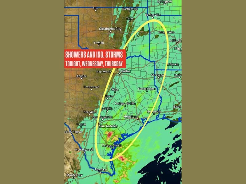
Showers and Isolated Storms Expected Across Central, Southeast, and East Texas Through Thursday as Cold Front Moves In
TEXAS — Scattered showers and isolated thunderstorms are expected to begin tonight across central, southeast, and east Texas, marking the start of a multi-day stretch of unsettled weather for the region. Forecasters indicate that these storms will continue on Wednesday and gradually spread northward.
Rain and Storms Through Midweek
The forecast shows a broad zone from San Antonio to Austin, College Station, Houston, and into eastern Texas positioned for repeated rounds of showers and isolated storm development. While the coverage will vary, moisture will remain plentiful enough to keep rain chances elevated.
By early Thursday, a cold front moving southeast through Texas will trigger another round of isolated storms, especially across the eastern half of the state.
Severe Weather Not Expected, but Heavy Rain Possible
Forecasters note that severe weather is not expected with this system. However, some areas may experience pockets of heavy rainfall, particularly in southeast Texas, where deeper moisture is present.
Cities within the impact region include Austin, San Antonio, Corpus Christi, Houston, College Station, and Shreveport’s surrounding areas just over the border.
What Residents Should Know
Although the storms are expected to remain below severe thresholds, Texans should be prepared for:
- Occasional downpours
- Lightning within isolated thunderstorms
- Slippery travel conditions at times
- Storms redeveloping as the cold front passes early Thursday
NapervilleLocal.com will continue monitoring the national weather pattern and provide updates as new information becomes available.

I’ve lived in Naperville long enough to see how quickly our community changes — from new developments downtown to sudden shifts in our Midwest weather. Reporting on Naperville news and daily forecasts gives me the chance to keep neighbors informed about what really matters. My goal is simple: deliver clear, timely updates so you always know what’s happening in our city and what to expect from the skies above.