
Slow-Moving Rain System Soaks Gulf Coast States From Louisiana to Florida, Bringing a Damp Weekend Stretch
MOBILE, ALABAMA — A stubborn, slow-moving rain system is crawling across the Gulf Coast this weekend, soaking cities from New Orleans to Jacksonville and showing little sign of moving out before early next week.
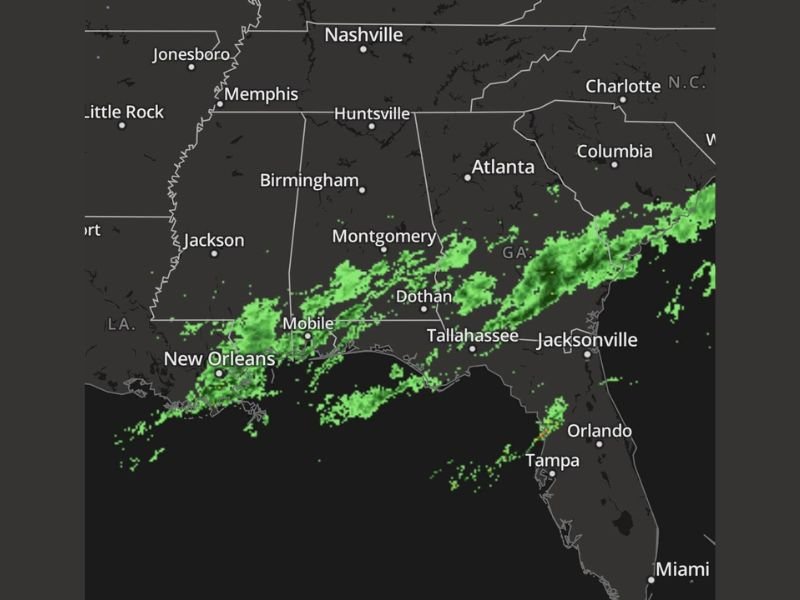
Radar imagery shows widespread light to moderate rain draped across Louisiana, Mississippi, Alabama, Florida, and southern Georgia, with the band of moisture slowly inching eastward at a snail’s pace. The system, fueled by lingering Gulf moisture and a stalled frontal boundary, has been producing persistent drizzle and cloudy skies since Friday evening.
Drizzle Turns into a Weekend Fixture
Meteorologists describe the system as “nearly stationary,” meaning it’s moving so slowly that it could keep steady rainfall in the same areas for several days.
As of Saturday morning:
- Mobile, Alabama has been dealing with drizzle since Friday, leaving roads damp and skies gray.
- Pensacola, Florida and the western Panhandle have seen intermittent light showers with temperatures hovering in the low 50s.
- New Orleans and surrounding parishes are under a widespread blanket of clouds, with occasional mist and reduced visibility.
Residents from Baton Rouge to Tallahassee can expect this soggy pattern to persist through at least Monday night, according to early model guidance.
“It’s like the rain unpacked its bags and decided to stay a while,” meteorologist Mike Boylan joked in a weekend update. “We’re not seeing much movement in this system — it’s just meandering along the Gulf Coast.”
Regional Impacts: From Wet Roads to Gloomy Skies
While rainfall totals are not expected to be severe, the duration of this system is the main story. A persistent drizzle could accumulate 1–2 inches in localized areas, keeping soil saturated and outdoor conditions damp.
Communities in southern Mississippi, coastal Alabama, and the Florida Panhandle will experience the most prolonged rainfall, with clouds and light showers extending as far north as Montgomery, Dothan, and Macon, Georgia.
Drivers are urged to use caution on slick roads, especially during evening hours when visibility will be reduced.
Looking Ahead: Clearing Expected by Midweek
Weather models suggest that the system will finally start to move eastward by Tuesday, allowing drier and slightly warmer air to filter into the region midweek. Until then, skies will remain mostly overcast, and temperatures will linger in the upper 40s to mid-50s across much of the Gulf Coast.
By Wednesday, forecasters expect clearer skies to return to Louisiana, Mississippi, and Alabama, though Florida’s Panhandle may still see a few lingering light showers early in the day.
Key Takeaways for Residents
- Persistent rain from Louisiana to northern Florida through early next week.
- Localized totals up to 2 inches possible in coastal regions.
- Temperatures holding steady in the 40s and 50s with minimal sunshine.
- Clearing trend likely by Tuesday night into Wednesday.
For now, Gulf Coast residents may want to keep umbrellas handy — because this weekend’s “sky juice” isn’t just visiting; it’s staying long enough to forward its mail.
Stay updated with reliable regional forecasts at NapervilleLocal.com.

I’ve lived in Naperville long enough to see how quickly our community changes — from new developments downtown to sudden shifts in our Midwest weather. Reporting on Naperville news and daily forecasts gives me the chance to keep neighbors informed about what really matters. My goal is simple: deliver clear, timely updates so you always know what’s happening in our city and what to expect from the skies above.