
Snow Finally Reaches Raleigh and Wake County as All 100 North Carolina Counties Record Snowfall and Road Conditions Deteriorate
RALEIGH, NORTH CAROLINA — Snow has officially reached Raleigh and Wake County, marking the final piece in a rare statewide winter milestone as all 100 counties in North Carolina have now reported snowfall.
After hours of uncertainty earlier in the day, radar data and surface observations confirmed snow moving into the Triangle region, with temperatures dropping into the upper teens, cold enough for snow to stick and rapidly affect road conditions.
Snow Confirmed Across Raleigh, Durham, and Surrounding Communities
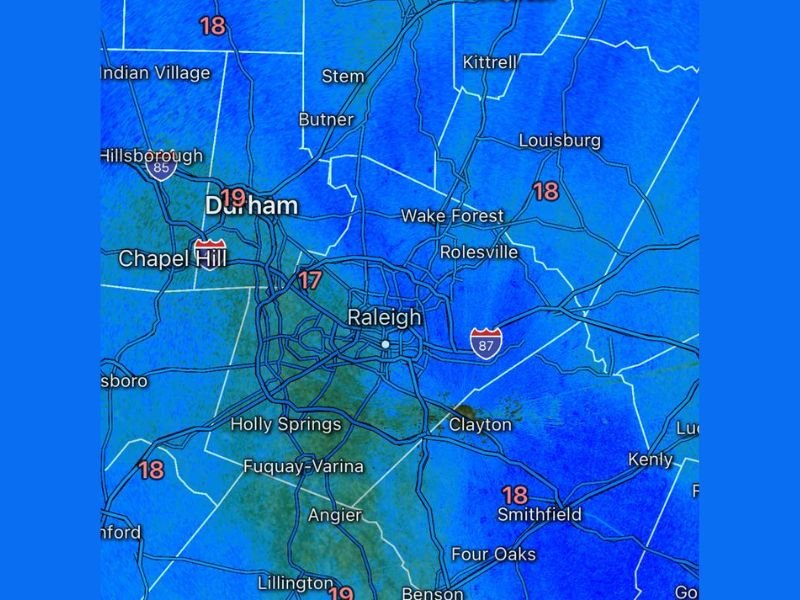
Weather data shows snow falling across Raleigh, Durham, Chapel Hill, Wake Forest, Rolesville, Clayton, Holly Springs, Fuquay-Varina, Smithfield, and Louisburg. Surface temperatures ranging from 17 to 19 degrees indicate that most precipitation is falling as snow rather than rain or mix. The arrival of snow in Wake County completes statewide coverage, an uncommon event for North Carolina winters.
Road Conditions Declining Rapidly Across the Triangle
Officials and residents report that road conditions have deteriorated quickly, especially on untreated roads, bridges, and secondary streets. With temperatures well below freezing, any snowfall is sticking immediately, creating slick and hazardous travel conditions. Drivers are urged to slow down, avoid unnecessary travel, and remain alert for black ice, particularly in shaded areas and on elevated roadways.
A Rare Statewide Snow Event for North Carolina
With snow now confirmed from the mountains to the coast and into the Triangle, this storm stands out as a rare statewide snow event. While snowfall amounts vary significantly by location, the widespread nature of the event has led to disruptions across the state, including abandoned vehicles, slowed emergency response times, and dangerous driving conditions.
Meteorologists note that even light snow can cause major impacts in North Carolina due to limited road treatment resources and rapid freezing.
What to Expect Next
Snow may continue intermittently through the night, and any additional accumulation will further worsen travel conditions. With temperatures expected to remain below freezing, melting will be slow, prolonging hazardous conditions into the next day. Residents are encouraged to stay off the roads if possible and monitor local alerts for updates.
Are you seeing snow or dangerous road conditions in Raleigh or elsewhere in North Carolina? Share your experience and stay with NapervilleLocal.com for continuing updates, radar analysis, and on-the-ground reports as this winter event continues.

I’ve lived in Naperville long enough to see how quickly our community changes — from new developments downtown to sudden shifts in our Midwest weather. Reporting on Naperville news and daily forecasts gives me the chance to keep neighbors informed about what really matters. My goal is simple: deliver clear, timely updates so you always know what’s happening in our city and what to expect from the skies above.