
Snowflakes Reported Across West-Central Florida as Rare Arctic Air Pushes Wintry Weather Into Tampa Bay Area
FLORIDA — Reports of snowflakes falling across west-central Florida early this morning are drawing attention as a rare Arctic air mass continues to surge deep into the peninsula, producing conditions almost never observed in the region.
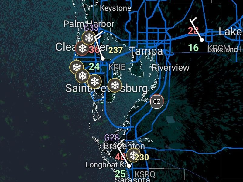
Snowflake Reports Centered Around Tampa Bay and Gulf Coast Communities
Weather observation data and spotter reports indicate snowflakes were observed near Clearwater, Palm Harbor, St. Petersburg, Tampa, and Bradenton during the early morning hours. Several weather stations in the region showed temperatures hovering in the mid-30s, with strong northerly winds creating a thermal profile cold enough for frozen precipitation to briefly reach the surface.
Icons and observations clustered along the Pinellas County coastline and Tampa Bay suggest the flakes were most likely light, intermittent, and short-lived, but visible enough for residents to notice — a highly unusual event for Florida.
Cold Air and Gulf Moisture Created a Brief Wintry Window
This rare setup developed as deep Arctic air moved south across Florida overnight while shallow moisture streamed inland from the Gulf of Mexico. The overlap allowed snowflakes or ice crystals to form and survive long enough to be observed before melting.
While radar returns were weak and accumulations were not expected, the temperature and wind data confirm the atmosphere briefly supported frozen precipitation in multiple locations across west-central Florida.
Temperatures and Winds Played a Critical Role
Surface temperatures across the region ranged from the low to mid-30s, with gusty north to northwest winds increasing evaporative cooling. These winds helped lower boundary-layer temperatures just enough for flakes to form, even as ground temperatures remained above freezing.
The strongest reports were concentrated near coastal communities, where onshore-offshore wind interactions and Gulf moisture enhanced the chance for brief flurries.
No Accumulation Expected, But a Historic Moment for Florida
Forecasters stress that no accumulation occurred or is expected, and roads remained unaffected. However, the significance lies in the rarity of the event itself. Snowfall reports in Florida are extremely uncommon, and even seeing flakes in the air places this cold outbreak among the most notable in recent decades.
Many longtime residents report never witnessing snowflakes locally, making this morning’s observations particularly remarkable.
Cold Conditions Continue Through the Morning
While snow chances fade quickly after sunrise, dangerously cold wind chills remain a concern, with temperatures slow to rebound through the morning hours. Frost and freeze impacts will continue to be more consequential than precipitation itself.
If you witnessed snowflakes or unusual wintry conditions where you live, share your experience. Stay connected with napervillelocal.com for continued coverage of this historic cold event and ongoing weather updates.

I’ve lived in Naperville long enough to see how quickly our community changes — from new developments downtown to sudden shifts in our Midwest weather. Reporting on Naperville news and daily forecasts gives me the chance to keep neighbors informed about what really matters. My goal is simple: deliver clear, timely updates so you always know what’s happening in our city and what to expect from the skies above.