
Snowflakes Reported in Inverness as Sensitive Radar Detects Snow and Mixed Precipitation Over Tampa Bay Area
FLORIDA — Reports of snowflakes falling in Inverness surfaced this evening as radar imagery from the Tampa Bay region began showing snow and mixed precipitation aloft across parts of west-central Florida. While surface temperatures remain just warm enough to limit accumulation, meteorologists say wet flakes could soon reach the ground in isolated areas.
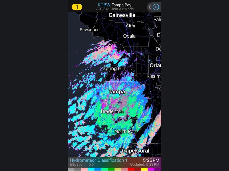
According to radar data, the activity was detected using clear air mode, a highly sensitive setting designed to pick up very light particles in the atmosphere. This mode is often required to identify snowflakes, which do not reflect radar signals as strongly as rain.
What the Radar Colors Are Showing
Radar imagery over the Tampa Bay area shows a combination of colors indicating different precipitation types:
- Blue represents snow
- Pink indicates a rain-snow mix
- Green shows rain
These mixed returns were observed over and near Tampa, Spring Hill, Bradenton, Ocala, Gainesville, and Inverness, suggesting frozen precipitation is present aloft even if not fully reaching the surface everywhere. Meteorologists caution that radar in clear air mode can appear overloaded, but the setup is intentional when attempting to confirm snow in marginal southern climates like Florida.
Why Snow Is Being Seen Aloft but Not Everywhere on the Ground
At the surface, temperatures are still just warm enough to prevent widespread frozen precipitation. However, colder air above ground level is allowing snowflakes to form and descend, with some melting before reaching the surface.
Forecasters say that as temperatures continue to cool, wet snowflakes may briefly reach the ground, especially during heavier bursts. Even brief flurries in Florida are considered notable due to how rare the conditions are.
Why This Event Is Unusual for West-Central Florida
Snow detection in Florida requires a precise combination of cold air, moisture, and lift. Even when flakes do not accumulate, radar-confirmed snow aloft and visual reports—such as those from Inverness—highlight just how uncommon and fragile this setup is.
The National Weather Service radar system is operating at its most sensitive level to capture any additional flakes that may develop overnight. Residents who observe snow or mixed precipitation are encouraged to document it safely, as these events are rare and short-lived in the region.
Have you seen flakes or wintry precipitation where you live? Share your photos, videos, or reports and stay updated with continued coverage at NapervilleLocal.com as this rare Florida weather event unfolds.

I’ve lived in Naperville long enough to see how quickly our community changes — from new developments downtown to sudden shifts in our Midwest weather. Reporting on Naperville news and daily forecasts gives me the chance to keep neighbors informed about what really matters. My goal is simple: deliver clear, timely updates so you always know what’s happening in our city and what to expect from the skies above.