
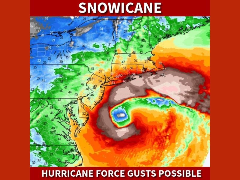
“Snowicane” Threat: Long Island and Cape Cod Brace for 80 MPH Gusts as Explosive Nor’easter Bombs Out Below 970mb
UNITED STATES — A rapidly intensifying Nor’easter is taking on characteristics more commonly associated with hurricanes, prompting forecasters to use the term “snowicane” as the storm bombs out offshore. Coastal areas of the Northeast, especially Long Island and Cape Cod, could experience wind gusts up to 80 mph, along with whiteout blizzard conditions and extremely high snowfall rates.
Forecast models show a well-defined eye-like structure forming as the low-pressure system strengthens dramatically over the Atlantic. Pressure values are projected to drop below 970 millibars, a level comparable to a Category 2 or even Category 3 hurricane in terms of central pressure. While this remains a winter storm, the atmospheric intensity is exceptional.
Hurricane-Force Gusts Along the Coast
The strongest winds are expected along exposed coastal regions, including:
- Long Island, New York
- Cape Cod, Massachusetts
- Portions of coastal Connecticut and Rhode Island
Wind gusts in the 60–80 mph range could down trees, damage power lines, and create widespread power outages. Combined with heavy snowfall, these winds may produce true blizzard conditions with near-zero visibility.
Explosive Strengthening Offshore
Meteorologists describe the system as “bombing out,” meaning the central pressure is falling rapidly over a short period of time. This rapid intensification is what gives the storm its hurricane-like structure on satellite and model imagery.
As the low deepens offshore, strong onshore winds will funnel moisture into cold air across the Northeast. That setup supports extremely heavy snowfall rates while simultaneously increasing wind speeds — a dangerous combination for anyone outdoors.
Blizzard Conditions and Whiteouts Likely
With heavy snow and hurricane-force gusts occurring simultaneously, whiteout conditions are likely in the hardest-hit coastal areas. Snow may accumulate quickly, while blowing and drifting snow will make travel treacherous or impossible.
Communities along the coast should prepare for:
- Prolonged power outages
- Dangerous coastal wind damage
- Impassable roads during peak storm intensity
- Severe reductions in visibility
A Storm for the Record Books?
Forecasters suggest this could become one of the more memorable winter storms in recent Northeast history due to its rare combination of extremely low pressure and blizzard conditions.
Residents in impacted areas should complete preparations immediately and avoid unnecessary travel as conditions deteriorate. For continued updates on major national weather events and developing storm systems, follow ongoing coverage at NapervilleLocal.com.

I’ve lived in Naperville long enough to see how quickly our community changes — from new developments downtown to sudden shifts in our Midwest weather. Reporting on Naperville news and daily forecasts gives me the chance to keep neighbors informed about what really matters. My goal is simple: deliver clear, timely updates so you always know what’s happening in our city and what to expect from the skies above.