
Solid Overnight Snow Band Pushes South Across Colorado, Bringing Light Accumulation From Fort Collins to the Front Range
COLORADO — A well-defined band of snow has developed across northern Colorado and is steadily sliding south through the night, delivering persistent snowfall from the Fort Collins and Greeley area through Denver and toward southern portions of the state.
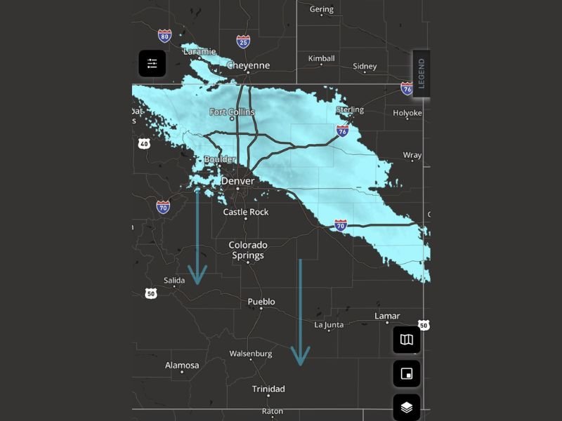
Radar imagery shows a continuous, organized snow shield, rather than scattered flurries, allowing snow to fall long enough in some locations to begin sticking to grassy and untreated surfaces.
Snow Already Accumulating in Northern Colorado
Reports from the northern Front Range indicate steady snowfall with visible accumulation on grass, particularly in western Greeley and surrounding areas. The snow intensity appears moderate at times, described as “snurrin pretty good,” which aligns with the solid radar returns over the region.
Because temperatures are supportive, snow is able to accumulate despite the absence of a major storm system, especially away from roadways.
Snow Band Sliding South Overnight
The orientation of the snow band shows a north-to-south progression, with the leading edge already extending across:
- Fort Collins
- Greeley
- Boulder
- Denver metro area
Arrows on the radar indicate the band continuing south toward:
- Castle Rock
- Colorado Springs
- Pueblo
- Southern Colorado corridors overnight
This suggests several more hours of snow potential for areas farther south as the band continues to drift.
What This Setup Means for Impacts
This is not a high-end winter storm, but the duration and organization of the snow band make it more impactful than brief snow showers.
Expected impacts include:
- Light accumulations on grass and elevated surfaces
- Reduced visibility at times under steadier snowfall
- Localized slick spots, especially on untreated roads, bridges, and ramps
Roads may remain mostly manageable, but conditions can vary quickly beneath heavier bursts.
Why This Snow Band Is Holding Together
The radar structure suggests persistent lift and moisture aligned with colder air, allowing snow to maintain coverage instead of breaking apart. This type of setup favors steady, low-intensity snowfall over several hours, which is often more effective at producing accumulation than short, heavier bursts.
Bottom Line
A solid, slow-moving band of snow is crossing Colorado overnight, bringing light but noticeable accumulation across the Front Range and continuing south into central and southern parts of the state. While not a major storm, the consistency of snowfall makes this a worth-watching overnight weather event.
For continued overnight weather tracking, regional radar breakdowns, and clear explanations of evolving winter patterns, stay connected with NapervilleLocal.com.

I’ve lived in Naperville long enough to see how quickly our community changes — from new developments downtown to sudden shifts in our Midwest weather. Reporting on Naperville news and daily forecasts gives me the chance to keep neighbors informed about what really matters. My goal is simple: deliver clear, timely updates so you always know what’s happening in our city and what to expect from the skies above.