
South Carolina, North Carolina, Georgia, and Virginia Face Low Snow Odds as Models Show Under 10% Chance Over Next 10 Days
SOUTHEASTERN UNITED STATES — After briefly flirting with spring-like warmth near 80 degrees, a cooler and more unsettled weather pattern is expected to take hold across parts of South Carolina, North Carolina, Georgia, and Virginia starting early next week, according to multiple global forecast models. The data, based on more than 150 forecast simulations from four major ensemble systems, shows that while colder air will move in, the probability of measurable snow remains very low across much of the Southeast over the next 10 days.
Warmer Weekend Gives Way to Cooler Pattern
Forecasters indicate that after the warm conditions on Saturday, a colder and potentially stormier setup begins moving in by Monday. This cooler pattern is expected to linger through much of the upcoming week. While some long-range models hint at a possible storm system late next week or next weekend, meteorologists stress that there are no guarantees at this time that anything significant will develop.
Why Snow Chances Remain Low
Even if a storm does form, timing and track will be critical. A small shift north or south could mean the difference between cold rain, no precipitation at all, or a brief wintry mix.
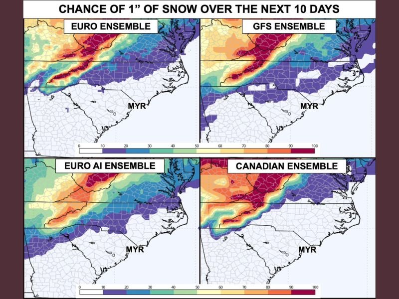
According to the ensemble guidance shown in the image:
- South Carolina and Georgia remain largely in the lowest probability zone
- North Carolina and Virginia show slightly higher chances, but still below 10%
- Coastal and southern areas have the least favorable setup for snow
In short, the atmosphere is not aligned properly for a widespread snow event.
What the Ensemble Models Are Saying
The forecast graphic includes data from:
- EURO Ensemble
- GFS Ensemble
- EURO AI Ensemble
- Canadian Ensemble
All four models consistently indicate that snow odds are under 10% across the region over the next 10 days. While this does not completely rule out snow, it signals that conditions are not favorable for accumulation.
Meteorologists note that it is historically difficult for snow to occur in this part of the Southeast. Everything must align perfectly — cold air, moisture, and storm track — and at the moment, those ingredients are not coming together.
Could the Forecast Change?
Yes — and forecasters are watching closely.
Weather patterns can evolve, and trends over the next 3 to 4 days will be important in determining whether snow probabilities increase or decrease. For now, however, confidence remains low for any wintry outcome. Residents hoping for snow may be disappointed, but the cooler temperatures will still bring a noticeable change from recent warmth.
What Residents Should Expect Instead
Rather than snow, most areas should prepare for:
- Cooler daytime highs
- Chilly overnight temperatures
- Periods of rain
- Unsettled conditions through much of next week
Any talk of snow should be viewed as conditional and uncertain, not a forecast lock.
Despite colder air moving into South Carolina, North Carolina, Georgia, and Virginia, current model guidance shows less than a 10% chance of seeing even 1 inch of snow over the next 10 days. While changes are possible, the odds remain stacked against a meaningful winter event. Stay updated with the latest weather developments, forecast analysis, and regional updates by following NapervilleLocal.com, and let us know what you’re seeing where you live.

I’ve lived in Naperville long enough to see how quickly our community changes — from new developments downtown to sudden shifts in our Midwest weather. Reporting on Naperville news and daily forecasts gives me the chance to keep neighbors informed about what really matters. My goal is simple: deliver clear, timely updates so you always know what’s happening in our city and what to expect from the skies above.