
Southeast Winter Storm Delivers Uneven Snowfall From Florida to the Carolinas, With Major Accumulations in North Carolina and Travel Disruptions Across the Region
UNITED STATES — A sprawling winter storm delivered highly uneven snowfall across the Southeast this weekend, producing everything from light flurries in Florida to crippling, double-digit accumulations in parts of North Carolina, according to regional snowfall reports and radar imagery.
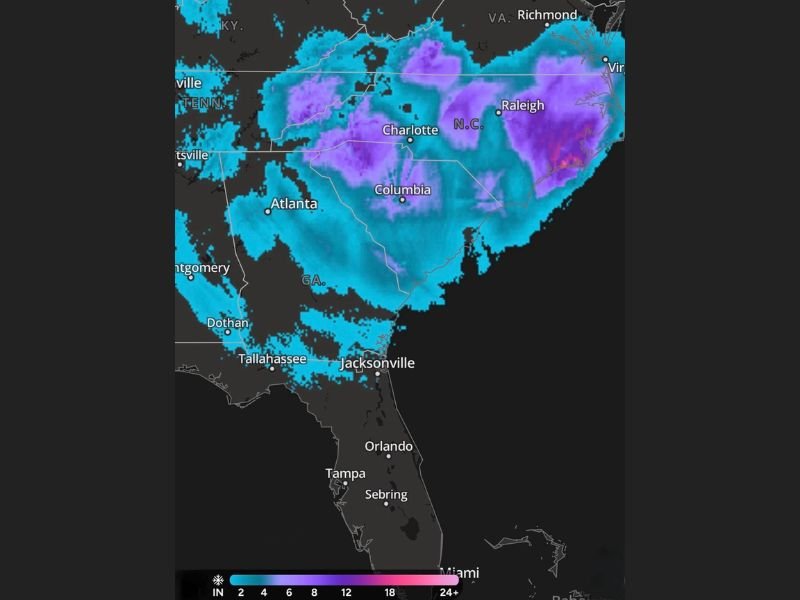
The storm’s impact stretched across Florida, Georgia, South Carolina, North Carolina, and portions of Virginia, with sharp contrasts in snowfall totals driven by banded precipitation and rapidly dropping temperatures.
Snow Reaches Deep Into Florida as Rare Flurries Are Reported
Snowfall was confirmed Saturday across northern Florida, with reports extending farther south than typical winter systems. Light snow and flurries were observed near Jacksonville, Gainesville, Ocala, Tampa, West Palm Beach, and Port St. Lucie, an unusual occurrence for late January.
Radar imagery showed narrow bands of snow rotating southward, allowing brief bursts of flakes even in coastal and central Florida communities. Accumulations remained minimal, but visibility reductions were reported in isolated areas.
Georgia Sees Widespread Snow and Major Traffic Impacts
In Georgia, snow spread rapidly across much of the state, with Atlanta reporting 2 to 4 inches in many neighborhoods. The snowfall led to widespread traffic disruptions, including vehicles abandoned along major highways such as Interstate 75, as road conditions deteriorated faster than treatment efforts could keep up.
The combination of freezing temperatures and steady snowfall caused travel conditions to worsen quickly across the Atlanta metro area.
Heavy Snow Blankets the Carolinas With Blizzard-Like Conditions
The most significant impacts were reported in North Carolina, where snowfall totals varied dramatically by location. Areas around Charlotte recorded 6 to 8 inches, while regions east of Raleigh saw 18 inches or more, forcing extended school closures and impassable roadways.
In South Carolina, Columbia experienced similar heavy snowfall, contributing to dangerous driving conditions and widespread delays. Snow bands intensified across the Carolinas, creating sharp gradients where totals increased rapidly over short distances.
Snowfall Distribution Highlights Storm’s Uneven Nature
The storm’s structure resulted in stark contrasts across the Southeast. While some areas saw only a light dusting, others were buried under more than a foot of snow. Radar data shows persistent banding across North Carolina and eastern South Carolina, explaining the extreme local variations in accumulation.
This uneven distribution left emergency crews responding to vastly different conditions across relatively small geographic areas.
Cold Temperatures Prolong Impacts Across the Southeast
Following the snowfall, cold air settled firmly across the region, slowing melting and allowing icy conditions to persist into the following days. Roads in shaded and untreated areas remain hazardous, particularly in locations that experienced heavier snow totals.
Officials continue to urge caution as cleanup and recovery efforts remain ongoing in the hardest-hit communities. Have you experienced snow or dangerous travel conditions in your area? Share your photos and updates with us in the comments and follow NapervilleLocal.com for continued regional weather coverage and breaking updates.

I’ve lived in Naperville long enough to see how quickly our community changes — from new developments downtown to sudden shifts in our Midwest weather. Reporting on Naperville news and daily forecasts gives me the chance to keep neighbors informed about what really matters. My goal is simple: deliver clear, timely updates so you always know what’s happening in our city and what to expect from the skies above.