
Southeast Winter Storm Locks In High-Confidence Snowfall Across North Carolina, South Carolina, and Virginia
North Carolina, South Carolina, Virginia — A strengthening winter storm is setting up a high-confidence snowfall event across large portions of the Southeast, with newly released forecast data showing near-certain snow totals exceeding three inches across multiple states unaccustomed to prolonged winter weather.
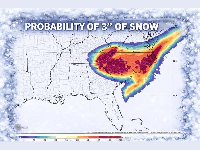
The latest 3-inch snow probability map highlights a widespread red zone, signaling areas where snowfall is no longer a question of if, but when. Meteorologists say the storm’s structure and cold air alignment make this one of the most confident Southeast snow forecasts of the season.
What the 3-Inch Snow Probability Map Confirms
The probability map does not measure final accumulation totals — it measures certainty. In the highlighted red zone, the likelihood of receiving at least three inches of snow approaches 100 percent.
The most affected regions include central and eastern North Carolina, large portions of South Carolina, and southern and eastern Virginia. Interior and coastal areas within this zone are expected to experience consistent snowfall rather than brief or mixed precipitation events.
Forecasters note that this level of confidence is uncommon for the Southeast, where marginal temperatures often limit snow potential. In this case, cold air is firmly established, allowing snowfall to accumulate efficiently.
Why This Storm Is Especially Disruptive for the Southeast
Unlike northern states, much of the Southeast lacks extensive snow-removal infrastructure. Even moderate snowfall can quickly lead to icy and impassable roads, school and government closures, power outages caused by heavy, wet snow, and extended travel shutdowns.
Because the storm is expected to linger for several hours, officials warn that conditions may deteriorate rapidly once snowfall begins, especially during overnight and early morning periods.
Travel, Power, and Infrastructure Risks
Major highways across the Carolinas and Virginia are expected to experience dangerous driving conditions, particularly in areas where snow is rare. Airports across the region may see delays or cancellations, while long-distance ground transportation could slow significantly.
Utility providers are preparing for potential power outages as snow accumulates on trees and power lines. Emergency managers are urging residents to plan for possible disruptions lasting beyond the end of the snowfall itself.
What Residents in the Impact Zone Should Do Now
Emergency planners recommend preparing ahead of the storm’s arrival by charging phones and backup batteries, limiting unnecessary travel, stocking food and household essentials, and checking heating systems before temperatures drop further.
Officials stress that response times may be slower than residents expect due to limited regional resources, making preparation especially important.
Why This Storm Matters Beyond the Southeast
Although this storm does not directly impact Illinois, winter storms in the Southeast often trigger nationwide ripple effects. Disruptions to air travel, freight routes, and supply chains can affect schedules and deliveries well outside the immediate snowfall zone.
Meteorologists also point out that this system reflects a broader pattern of volatile winter weather, where sharp temperature contrasts allow storms to intensify quickly and produce high-impact outcomes across multiple states.
As forecasts continue to refine snowfall timing and intensity, residents across North Carolina, South Carolina, and Virginia are urged to remain alert and prepared. NapervilleLocal.com will continue monitoring significant national weather events that may affect travel, logistics, and regional stability across the Midwest and beyond.

I’ve lived in Naperville long enough to see how quickly our community changes — from new developments downtown to sudden shifts in our Midwest weather. Reporting on Naperville news and daily forecasts gives me the chance to keep neighbors informed about what really matters. My goal is simple: deliver clear, timely updates so you always know what’s happening in our city and what to expect from the skies above.