
Southern California and Desert Southwest Brace for Heavy Rain and Flooding Threat Saturday
LOS ANGELES, Calif. — A powerful Pacific storm system is expected to bring heavy rainfall and a heightened flood risk across Southern California, the Los Angeles Basin, and into parts of the Desert Southwest through Saturday, according to updated weather models and meteorologists.
Forecasters warn that widespread rain and thunderstorms could lead to localized flash flooding, particularly in Los Angeles County, San Diego, and areas near burn scars left by past wildfires. Rainfall rates may reach up to one inch per hour in some spots, creating hazardous travel conditions and the potential for mudslides.
Widespread Flood Threat Across the Southwest
Meteorologists say flooding will be “increasingly likely” beginning late Friday night and continuing through Saturday evening as the storm tracks eastward.
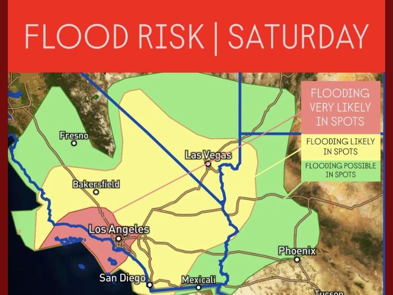
The National Weather Service has placed parts of Southern California, western Arizona, and southern Nevada under flood advisories. The areas of greatest concern include:
- Los Angeles Basin — Flooding very likely overnight through Saturday, particularly in foothill and canyon regions.
- San Diego County — Heavy rainfall expected with potential for flash flooding near low-lying coastal neighborhoods.
- Bakersfield and Fresno — Moderate rainfall and flooding possible, especially in areas with poor drainage.
- Las Vegas Valley — Risk of heavy showers and localized flooding Saturday afternoon.
- Phoenix and Western Arizona — Isolated downpours could cause minor flooding, particularly in desert washes.
Recent Burn Scars Pose Added Risk
Forecasters emphasize that regions impacted by recent wildfires face an elevated danger of mudslides and debris flows. The Angeles National Forest, Santa Monica Mountains, and Inland Empire foothills are all under close monitoring for potential slope failures and flash flooding.
“With the ground already loose and unable to absorb large rainfall amounts, even moderate storms could trigger debris flows in burn areas,” meteorologists cautioned.
Communities such as Malibu, Pasadena, and the San Gabriel Valley are urged to remain alert overnight and prepare for rapidly changing weather conditions.
Expected Rainfall and Flooding Timeline
Rainfall totals through Saturday could range between 2 and 4 inches across coastal and valley areas, with higher elevations potentially seeing up to 5 inches of precipitation.
The heaviest rainfall is expected between midnight Friday and 10 a.m. Saturday, followed by lighter showers throughout the afternoon.
Forecasters say flash flooding is possible during the peak rain window, especially where rainfall rates exceed one inch per hour. Motorists are urged to avoid driving through flooded intersections or low-lying roads.
Storm System Extending Into the Desert Southwest
After impacting Southern California, the same storm will push east toward Las Vegas, Phoenix, and Tucson, carrying the threat of thunderstorms, gusty winds, and desert flooding.
This could make travel difficult along major interstates, including I-10, I-15, and I-40.
Officials advise travelers to check road conditions and allow extra time, as desert washouts and lane closures are possible through Saturday night.
Emergency Preparedness and Safety Measures
Authorities are urging residents to stay prepared by:
- Keeping emergency kits, flashlights, and backup batteries on hand.
- Avoiding canyon roads and mountain passes during heavy rain.
- Monitoring weather alerts from the National Weather Service and local agencies.
- Clearing storm drains and gutters to prevent home flooding.
- Avoiding hiking or outdoor activities in areas prone to flash flooding.
Looking Ahead
While the heaviest rain will taper off by late Saturday, scattered showers could linger into Sunday morning.
Forecasters expect a brief break early next week before another potential Pacific storm approaches midweek, which could bring renewed rain chances for California.
Residents across the Los Angeles Basin, San Diego County, and inland valleys are urged to stay weather aware overnight and avoid unnecessary travel until conditions improve.
How is your area preparing for the flood risk this weekend? Stay informed and share local updates at NapervilleLocal.com.

I’ve lived in Naperville long enough to see how quickly our community changes — from new developments downtown to sudden shifts in our Midwest weather. Reporting on Naperville news and daily forecasts gives me the chance to keep neighbors informed about what really matters. My goal is simple: deliver clear, timely updates so you always know what’s happening in our city and what to expect from the skies above.