
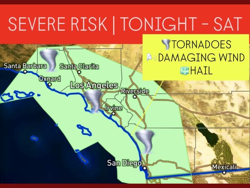
Southern California Faces Severe Storm Threat from Santa Barbara to San Diego Through Saturday
LOS ANGELES, Calif. — Meteorologists are warning residents across Southern California’s coastal corridor to brace for severe thunderstorms, damaging winds, and isolated tornadoes through Saturday evening as a powerful storm system moves inland from the Pacific.
The system has positioned itself in a highly favorable setup for rotating thunderstorms, putting areas from Santa Barbara to Los Angeles and down to San Diego under elevated weather alerts. The severe threat window runs from 6 p.m. Friday through 6 p.m. Saturday, according to regional forecasts.
Storm Setup and Areas at Highest Risk
Weather experts say this system combines abundant moisture, upper-level instability, and shifting coastal winds, creating ideal conditions for thunderstorms capable of producing weak tornadoes and waterspouts, along with heavy rain and hail.
Cities and communities at greatest risk include:
- Santa Barbara and Ventura County coastlines, where initial storm cells are expected to form Friday night.
- Los Angeles and Orange Counties, including Santa Clarita, Oxnard, and Irvine, where rotating storms could trigger short-lived tornadoes or strong wind gusts.
- San Diego County, where storms may intensify late Friday night into early Saturday, bringing potential for flooding and lightning.
“This setup is unusual for mid-November,” meteorologists noted. “Moisture off the Pacific combined with a cold upper low is giving rise to an environment capable of severe coastal storms.”
Threats Include Tornadoes, Damaging Winds, and Hail
Forecasters warn that thunderstorms could produce brief, weak tornadoes or waterspouts over coastal waters, along with wind gusts up to 65 mph.
Small marble-sized hail, frequent lightning, and flash flooding are also possible during the height of the storms.
The National Weather Service (NWS) has advised residents to secure outdoor objects, avoid unnecessary travel, and monitor local alerts for updates throughout the weekend.
Timing and Storm Progression
- Friday Evening (6 p.m. – Midnight): Initial thunderstorms expected along the Santa Barbara and Ventura coasts, expanding inland toward Los Angeles County.
- Early Saturday Morning: Storm activity shifts southward through Orange County and the Inland Empire, with lightning and isolated flooding possible.
- Saturday Afternoon (Noon – 6 p.m.): The line of storms is expected to reach San Diego County, bringing heavy rain, potential hail, and strong wind gusts.
Forecasters noted that brief tornado touchdowns cannot be ruled out anywhere along the coastline during this window.
Flooding and Lightning Concerns
While tornadoes are the rarest threat, flooding remains a major concern, especially in urban areas and burn scar zones.
Rainfall rates could reach up to one inch per hour, causing dangerous conditions on roads and freeways.
Low-lying areas of Los Angeles, Riverside, and San Diego counties are most vulnerable to flash flooding, while elevated regions may experience localized mudslides.
“If you live near canyon roads or recently burned hillsides, remain alert,” officials said. “Do not attempt to cross flooded intersections or drive through standing water.”
Safety Precautions and Preparedness
Authorities urge residents to take the following safety measures through Saturday:
- Stay indoors during thunderstorms and avoid using electrical appliances.
- Secure patio furniture, umbrellas, and other items that can be blown away.
- Avoid coastal waters where waterspouts and lightning pose significant risks.
- Have a weather radio or alert-enabled phone for emergency notifications.
Travelers using major routes such as Interstate 5, Highway 101, and Interstate 15 should expect delays due to flooding and reduced visibility.
Looking Ahead
By Saturday night, the storm system is expected to move eastward toward Arizona and southern Nevada, gradually ending the severe threat for coastal California.
However, lingering showers may persist into Sunday morning, especially in Los Angeles and Orange counties.
Meteorologists continue to track additional Pacific systems that could bring more rain to the region next week.
Residents are urged to stay weather-aware and follow all local updates until the severe weather risk subsides.
Have you seen the storms moving in your area? Share your local updates and safety tips at NapervilleLocal.com.

I’ve lived in Naperville long enough to see how quickly our community changes — from new developments downtown to sudden shifts in our Midwest weather. Reporting on Naperville news and daily forecasts gives me the chance to keep neighbors informed about what really matters. My goal is simple: deliver clear, timely updates so you always know what’s happening in our city and what to expect from the skies above.